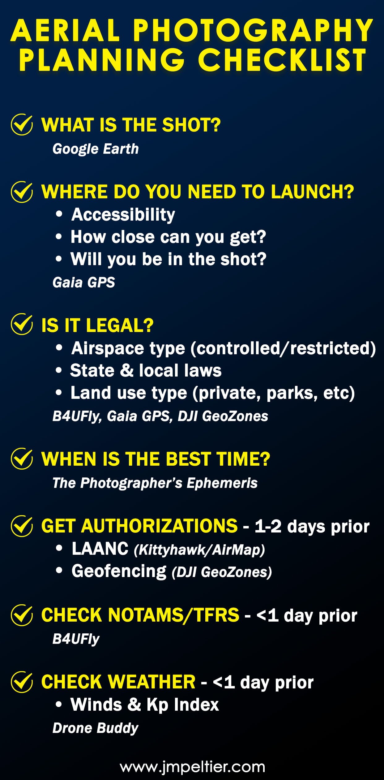
Aerial Photography Planning Checklist & Resources [Download]
Disclosure: This post may contain affiliate links. I earn a small commission of product sales to keep this website going.
Serendipity can be a wonderful thing. Just going out with your drone and seeing what kind of magic you can make with it.
But there's also something to be said for proper aerial photography planning. There is a lot to consider, and the more you can do ahead of time, the better drone photos you can get!
In this post, I'm going to take you through my aerial photography planning process based on a current photography project I'm doing, where I'm using aerial photos to help tell the story and compliment "regular" photos.
You can download everything in a smartphone-sized checklist at the end.
Long-range planning your aerial photography
If I've got a project I'm working on, I may start planning aerial photos months in advance. But you don't need to - this stuff can all happen day-of.
Regardless of when you start it, these are the steps you should do first.
What is your vision for the shot?
Do you have a particular shot in mind? If you're going to be using the photo to help tell a story, you probably have a good idea of what you want the final photo to look like.
Or maybe you just want to capture some aerial photos of a particular area without any specific storyboarding. That's all good too!
Either way, the first thing you want to do is to identify what you want to create aerial photos of.
It may seem obvious, but some folks will just blindly wander around and see what happens. That's the serendipity that I mentioned in the beginning. But we're on a mission here. Time is money, and we have limited flight time.
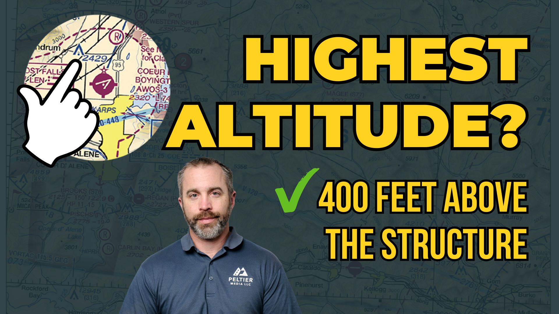
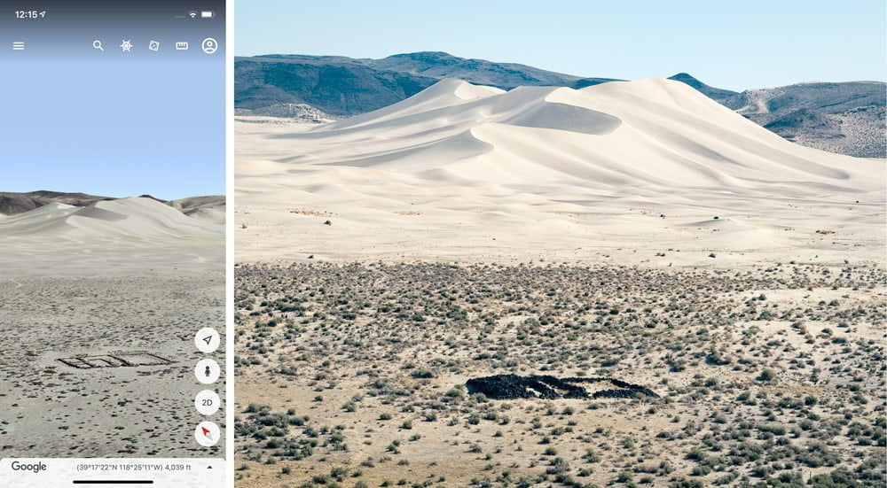
One super-valuable app for location scouting at home is Google Earth. It's a free app and has high-resolution imagery with three-dimensional terrain to help you envision potential photos. It also has an altitude reading as you're flying around the app to help you ascertain your max 400' AGL altitude.
In this example that we'll be using for the rest of the article, I wanted to capture a photo of the ruins of the Sand Springs Pony Express Station. So-called Sand Springs because of the large, out-of-place sand dunes next to the station. My vision was to create a low-angle aerial photo of the ruins in the foreground with the dunes in the background.
Here's what Google Earth previewed and one of the images I created later.
Where do you need to launch from?
Knowing your foreground and your background will dictate the direction in which you're photographing. Or in some instances, you'll be looking straight down.
When determining where you'll be launching from to get that photo, consider the following:
- Will it even be legal? That's covered in the next section.
- How will you access the area - foot, car, boat, ATV, bicycle, horse...?
- How close can you get to your desired shot location? Can you park your car right below where your drone will be, or will you need to fly it a ways from the end of the road? Will you be able to keep the drone in sight?
- Will your launch zone be in the way of the shot, like if you're too close to the subject? If so, where can you relocate?
For the above example, the area I wanted to fly over to get the shot is closed to vehicles. I wanted to use my Inspire 2 to use a particular lens, and didn't necessarily want to schlep that through the sand. Thankfully there's a dirt road with a large clearing close enough to my subject, but still far enough where I wouldn't be in the shot.
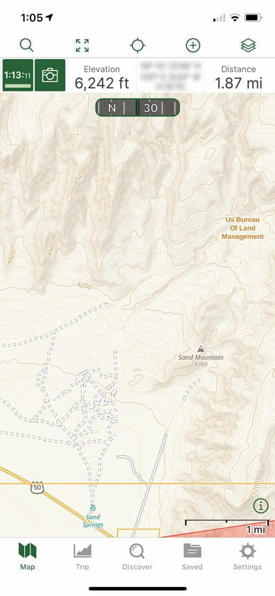
I figured all of this out using the Gaia GPS smartphone app; you'll read more information about it in the next section.
Is it even legal?
Once you know the shot you want and where you need to launch from to get that shot, you need to determine if that's even legal. What's the point in progressing with your aerial photography planning if it's all moot?
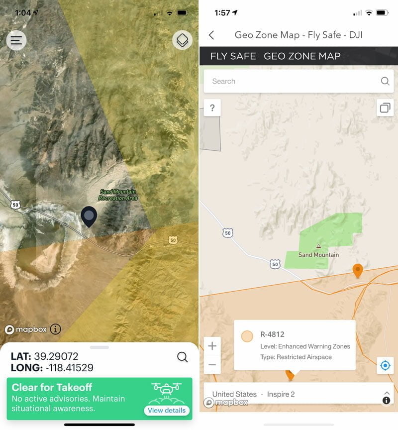
The FAA has a smartphone app called B4UFLY that will show you controlled airspace, military airspace, National Parks, and a few other restricted areas. The app used to be garbage but it is now very useful after they paired up with the Kittyhawk developers (now Aloft). It doesn't have all restricted areas, but it's a good planning tool.
You'll also want to check the DJI GeoZones since this has additional restricted areas. You'll need to get some sort of authorization for these areas; this article has these instructions.
What does the FAA say?
If you're a certified Part 107 pilot, hopefully you know where you can and can't fly with regards to the FAA regulations.
You might be outright prohibited from flying the mission, like if it's in a Prohibited Area.
Or maybe it's in an area that requires additional authorizations - either because of controlled airspace or military activity.
You can read this article about getting airspace authorization using LAANC. The article has the word recreational in the title because I wrote it when the FAA started requiring LAANC authorizations for recreational pilots, but the procedures are more or less the same for everyone.
Nearly all of these areas are in the B4UFLY App.
What about state & local government?
Different states and municipalities have different laws regarding where drones can and can't fly, mostly relating to privacy laws.
Do an Internet search for "[your area] drone laws" and you should find something.
An absence of information doesn't necessarily mean it's legal, but as long as you've done your due diligence, that might be enough if questioned by law enforcement.
And again, getting your Part 107 certificate can go a long way when questioned by authorities.
These are not covered in the B4UFLY App.
Who owns the land?
Definitely DO NOT trespass onto private property to launch a drone. If you need to get onto private property to launch, always ask the property owner first, and in writing if you can.
There are some other instances where even though the land is public, drone flight is prohibited. This is true for Congressionally-designated Wilderness areas, National Parks, some state parks, nature preserves, and so on.
If you want to launch from public lands with a special designation like "wildlife area", "recreation area", "state park", etc., check on the drone laws before flying.
Most of these considerations are not covered in the B4UFLY App. The Gaia GPS app does have a Private Land overlay so you can see who owns the land, based on public records. You can read this article about how I use Gaia for photography planning.
For our example, I went to B4UFLY to check on federal restricted airspace. I see that it's sandwiched between a Restricted Area and a Military Operations Area. Tapping on my flight area, it tells me I'm cleared for takeoff. But what about the land use? Going to Gaia GPS I see that it's on BLM land. BLM land is generally fair game unless it's a sensitive area where drone flight is specifically prohibited.
Looks like I'm legal to launch and get the shot I want.
What time would be best?
Are you going to just go out there at any time and get the photo? No! We're photographers. We write with light - light matters.
I always want to know which season and which time of day I want to create the photographs.
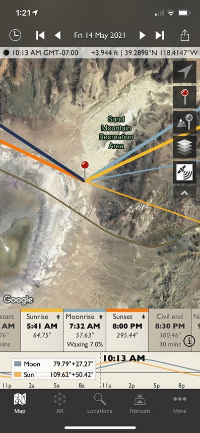
If I want to get the first or last light of day, I want to know when the sun will be at the horizon for that location. For this, I'll use The Photographer's Ephemeris (TPE) app.
This wonderful photography app can do all sorts of things, like telling you exactly when and where the sun will be at the horizon throughout the year, help you calculate shadow length, and more. You can read this article to learn more about TPE and its competitor PhotoPills (both great).
And here's another article about using the geodetics feature to make sure you have the sun exactly where you want it.
There's also a 3D version of TPE called...TPE 3D. This can be useful in mountainous environments to help visualize terrain shadows throughout the day. The desktop-version of Google Earth also has a "sunlight" simulator that can do the same thing.
I wanted the some good low light to really make the shape of the sand dunes stand out. In the middle of the day it just looks too flat. So do I go in the morning or evening? Looking at TPE, I see there's not much of a difference in the sun angle between morning and evening. But since I'll be driving by in the morning on a specific trip, morning will work just fine.
Which lenses should you consider?
This is aimed at photographers who have aerial cameras with interchangeable lenses.
Which lenses will help you with the vision & story that you have?
I wanted a wide-angle view to show the expanse of the place. But I also wanted a telephoto view to "bring the dunes closer", helping them appear bigger, to loom over the ruins.
These considerations are just to know which lenses to put on your camera, to make the most out of your flight time.
Short-range planning your aerial photography
What do you do when game day gets here?
These are the things you want to check starting within 24 hours of your flight.
Do you have the proper authorizations?
If you did need to get LAANC authorization for your flight (for FAA controlled airspace), make sure that's been approved and that you have your authorization number available during the flight. Here's that link one more time for getting LAANC authorization.
But wait! Even if you did get LAANC authorization - or if LAANC authorization wasn't even required - you might need to unlock DJI's GeoZones too. DJI utilizes geofencing to keep pilots out of restricted areas without permission (if permission is available).
Make sure you unlock the DJI GeoZones before you go out of cell phone service. Read this article for information on unlocking geofencing. You can do this a few days in advance but will need the authorization loaded into the drone before flight.
Are there any new NOTAMS or TFRs?
Flight restrictions can pop up at the last minute - between when you first planned your mission and when you're launching.
Right before you launch - while you still have cell phone reception - check the B4UFLY app one more time to make sure there are no Temporary Flight Restrictions (TFRs) that will affect your flight.
How is the weather?
Does your desired shot require an overcast cloud layer? Or sunlight? How's that looking? I'll start looking at sky coverage a few days in advance to see when I'll get my desired effect.
Winds can also be an important thing to know. Drones have wind limits, which has to do with controllability. If a gust hits your drone so hard that it can't compensate in time, you may lose control.
But flight time also has a lot to do with it. If you fly your drone 1,000 feet away from you with a 40-knot tailwind, that drone is going to haul ass out there!
And when it's time to come back? You can push on that control stick as hard as you can and that drone is going to crawl back at one or two miles per hour thanks to that 40-knot headwind. Then your battery dies while it's still 800 feet away from you.
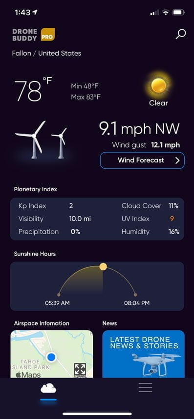
The other obscure "weather" thing to check is the GPS forecast. How well will your drone be able to navigate and maintain position? In the forecast this is called the Kp index. It's on a scale of 1-9, with high numbers meaning a high degree of magnetic disturbances in the atmosphere, which will negatively affect GPS.
Drone Buddy is a really simple weather app that can give you all of this information. You can get the minimum amount of information needed with the free version; the Pro version (an affordable upgrade) will give you extended forecasts and more.
In Closing
These are all just the things to consider when planning aerial photos. There's of course the maintenance, making sure your batteries are charged, firmware is updated, all that jazz that you should be doing anyways.
But hopefully, these aerial photography planning steps will help you get better photos!
App List
Here's a succinct list of all the apps mentioned in this article:
- B4UFLY - FAA airspace restrictions, TFRs
- Google Earth - Scouting locations
- The Photographer's Ephemeris / PhotoPills - Planning your lighting
- Gaia GPS - Planning photography projects; land use
- Aloft (formerly Kittyhawk) / AirMap - LAANC authorizations
- Drone Buddy - Weather
You can do most of these functions - checking TFRs, getting airspace authorization, checking the weather, and more - in the Aloft app, and that'll be the subject of a future article.
This article contains some more of my favorite photography planning apps.
Checklist
You can just right-click on this JPEG file to save it to your computer or phone. Use it to make sure you've got all of your bases covered when doing your aerial photography planning!