Disclosure: This post may contain affiliate links. I earn a small commission of product sales to keep this website going.
Using Geodetics with The Photographer’s Ephemeris
The other day I wanted to stand above Emerald Bay, Lake Tahoe and shoot a time lapse of the sun rising over Fannette Island. Sunrise was at 0624 but there’s some high mountains across the lake. This gave me a few problems to figure out:
- When will the sun actually appear over the mountains opposite the lake?
- Where on the horizon will that be?
- When should I start my time lapse to run 10 minutes before to 10 minutes after we see the sun?
 Fortunately this is fairly quick & easy with the Geodetics function of The Photographer’s Ephemeris (hereafter referred to as TPE). It told me that:
- The sun would peek over the mountains at 0633 (9 minutes after Sunrise)
- The sun would shift two degrees to the south during that time
- My time lapse should run from 0623 to 0643
Don’t have The Photographer’s Ephemeris? Get it here: For Apple | For Android
TPE did just come out with a 3D version that has blown my mind, stand by for a review soon.
What is Geodetics?
Geodetics uses terrain elevation data to figure out line-of-sight between two points of different elevations. Set Point A in a valley and Point B on a ridge, and it calculates angular information from A to B and vice-versa.
If you’re looking 10 degrees up from Point A to Point B, then you won’t be able to see the sun until it’s at least 10 degrees high.
It’s easy to calculate where and when the sun will rise & set in flat terrain, but put a big mountain in the way and that changes everything. Enter TPE’s Geodetics.
These calculations can be used for the moon as well. It’s also useful for figuring out when you’ll be in the shadow of a mountain, or when you’ll be out of that shadow if you’re waiting for sunlight.
How to use Geodetics with The Photographer’s Ephemeris app
Important note: while most ephemeris data is available offline, you must have a data connection to use geodetics. Take this into account if you’re going into the backcountry – plan early!
I first had to figure out the general location where I should stand to get the sun rising over the island. This is one of the most basic functions of TPE. I just moved the red pin around until the thick yellow line (indicating sunrise azimuth) was over the island.
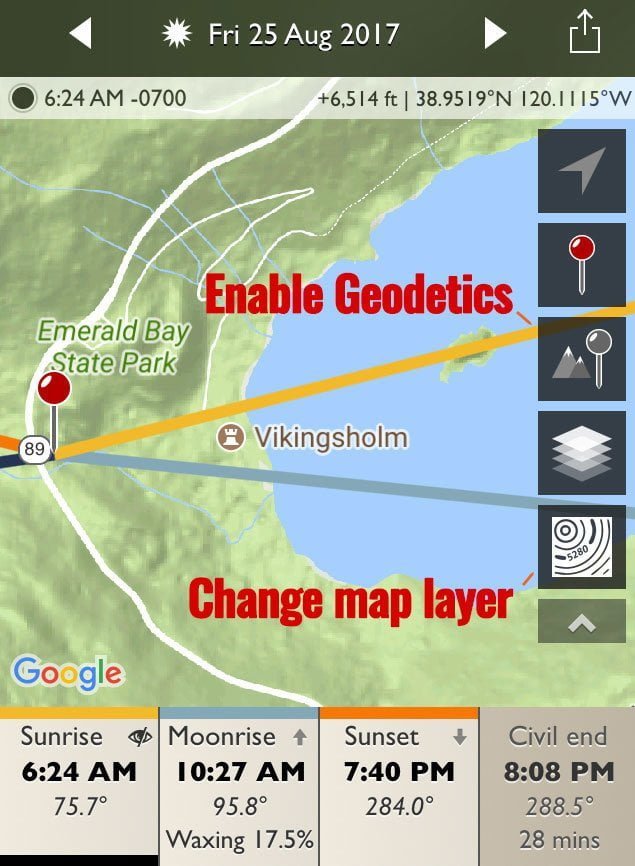
I had to enable Geodetics next to figure out where & when the sun would rise on the other side of the lake.
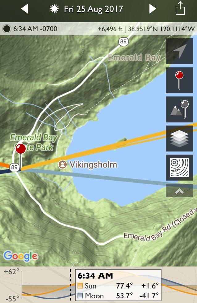
- Geodetics is easier to use with the Google Terrain map layer. Select the bottom icon in the column on the right. In this submenu select the icon that looks like the rings on a tree – contour lines of a map (see above photo).
- Enable Geodetics. This is the icon on the right that has a gray pin with mountains (see above photo). Easy to remember, right?
- I panned the map over to the highest terrain between me and sunrise. Based on local knowledge I knew this would be to the south of Genoa Peak.
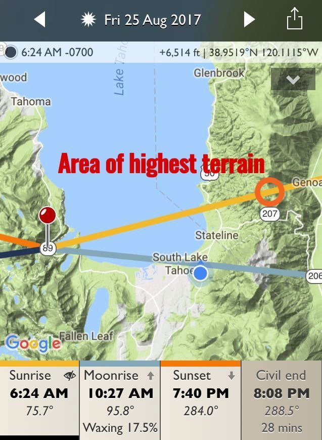
- I put the crosshairs right on the ridge near the sunrise azimuth and dropped the gray pin.
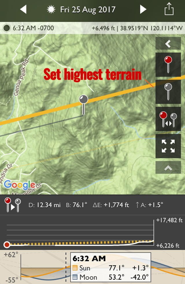
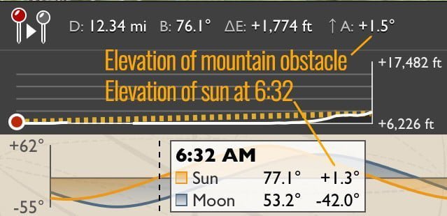
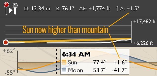
- Now you’ll get some more information below the map. There’s a bunch of numbers on the top showing distance, bearing, elevation change, and angular change from the red pin to the gray pin. Note that from my position to the top of the ridge I’m looking up 1.5 degrees. At 0632 the sun will be 1.3 degrees high – so, behind the mountain. That’s why the yellow line on the graph is dashed.
- Use the time slider to change this yellow line in the graph from dashed to solid. In this case, at 0634, the yellow line solidifies and the sun is 1.6 degrees high – above the ridge.
- Then I panned back over to the island to see where the sun would be when it comes above the mountains. This is the thinner yellow line. It shows just to the right side of the island.
- Final step: don’t forget to set alarm, and don’t snooze through it.
The results
Well, the time lapse didn’t turn out too well so here’s a still photo instead. This shot was taken at 0633, pulled from the EXIF data. And you can also see how the sun is rising on the right side of the island. All just as predicted!

Now go forth and conquer!
Don Janzen
Monday 5th of April 2021
Thank you for this excellent article. I’ve been using TPE as a basic when and where for sun and moon. I’m looking forward to adding the geodesic function Too much fun
John Peltier
Monday 5th of April 2021
It's crazy what we can do with computers now...ones that fit in our pockets, no less :)