The Five Best Apps for Travel & Landscape Photographers
Disclosure: This post may contain affiliate links. I earn a small commission of product sales to keep this website going.
This is a list of my favorite landscape photography apps, invaluable for backpacking, hiking, and travel. These photo apps will aid you throughout the entire process, from planning to capture to editing.
There are plenty of more specific apps out there, but these are the generic must-have photography apps for any outdoor photographer.
To learn how to integrate these into planning aerial photographs, you can head over to this article.
My first two apps on this list are PhotoPills and The Photographer's Ephemeris (TPE). These are two incredibly detailed and essential photography planning apps. For a detailed comparison of PhotoPills and TPE, head over to this post.
1. PhotoPills
PhotoPills for iOS | Android - $9.99
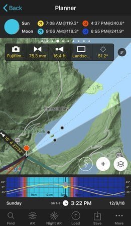
PhotoPills has replaced The Photographer's Ephemeris as my favorite landscape photography app for knowing everything I need to know about the sun & moon. It's extremely easy to use and has a beautiful interface. However, it's packed with features and you may find this overwhelming. In that case, check out TPE. This bundle of features includes:
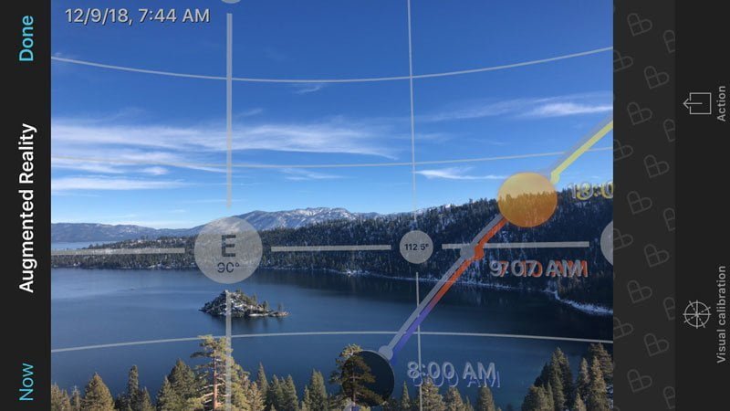
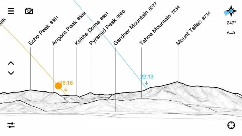
- Celestial Almanac - useful information for the sun, moon, and Milky Way. Rise & set times, locations, strength, azimuth, brightness, etc. An Augmented Reality (AR) mode overlays the sun and moon over your phone's camera so you can see where they will be throughout the day. If you want AR with the names of peaks also, check out PeakFinder AR (below).
- Planner - save upcoming shoots based on celestial events. Use the map to find out where you should stand to photograph an eclipse over a geologic feature, and when. Or just save your favorite shooting locations and figure out what the sun, moon, and Milky Way will be doing at certain times from that location.
- Exposure Calculator - easily calculate corrected exposures based on different types of neutral density filters, useful for long exposures.
- Focusing Aids - set your favorite camera and get useful depth of field charts, calculators, and hyperfocal distance tables based on your lenses.
- Astrophotography Tools - find the proper exposure times to avoid star trails, or calculate what star trails will look like based on where your camera is pointing and how long the exposure is. A built-in timer will aid this. A Night AR mode will overlay celestial objects on your phone's camera, so you can see where the Milky Way will be throughout the night.
- Field of View tools - find out how large your camera's field of view is for certain lenses and how far away from objects you must be to fit them in the frame. The field of view also overlays on a map so that you can see which geographic features your lens will include, or find out what focal length you need to exclude certain features.
- An Academy and Social Feature will teach you how to use the app, how to take better outdoor photos, and let you share with the rest of the community.
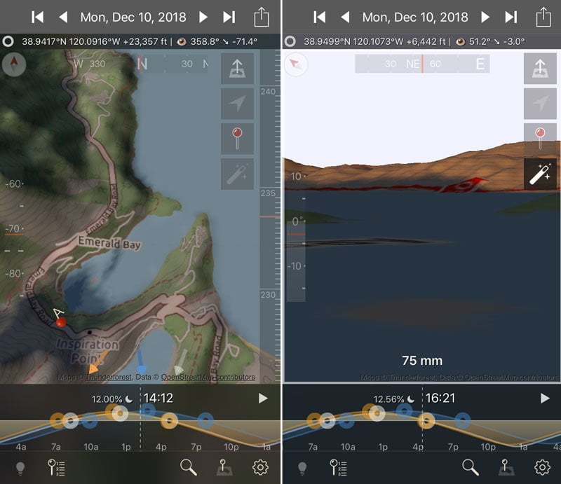
2. The Photographer's Ephemeris 3D
TPE 3D for iOS | Not yet available for Android - $11.99
The Photographer's Ephemeris 3D uses complex maps and digital elevation data to help you plan shots in ways that PhotoPills can't, though it's missing many of the features and ease-of-use found in PhotoPills.
One of the things I love most about it is the shading feature - you can "play" a sunrise or sunset and see how the shadows will act. This also gives you access to the same celestial data that PhotoPills does, as well as 3D focal length planning, though the interface isn't as easy to use. A data connection is required for elevation information.
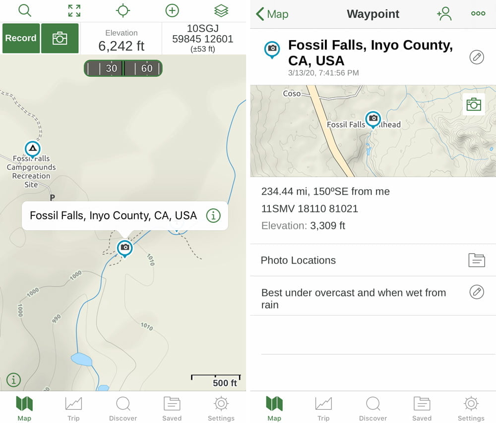
3. Gaia GPS
Gaia GPS for iOS | Android - Subscription levels Free to $39.99/yr
Gaia GPS has been my favorite hiking app for years and I also incorporate it into photography outings.
It has a wide variety of maps available, from nautical to National Geographic Trail maps to aviation charts. You can layer the maps on top of each other and adjust opacity. Create shapes and routes. Record your tracks, check your stats, and download the GPX file from the cloud. Save maps for offline use while in Airplane Mode.
That's great for hikers and backpackers, but how is it a landscape photography app?
Import the GPX file into a program like Lightroom or Photo Mechanic and instantly geotag your photos. Know exactly where you were on the trail when you took your photos and increase SEO for your online photo gallery.
I also use it to record waypoints of my favorite photography places, or locations I'd like to return to with notes about the best time for photography, which lenses to bring, etc. On a bigger scale, I use it to plan long-term photography projects.
Read my full review here for a description of the app and pricing plans. It's affordable and well worth it.
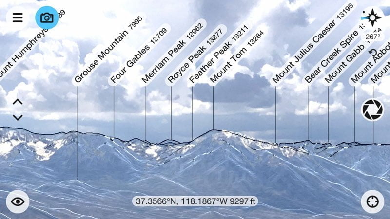
4. PeakFinder AR
PeakFinder AR for iOS | Android - $4.99
PeakFinder AR isn't advertised as an app for photographers, but it's super useful as one. It's not just a great navigational aid, but it'll also help you identify the peaks that you're shooting.
Why is this important? Why wouldn't you want to know!? And if you're selling stock, you need to keyword as much information about the photo as possible.
Like the PhotoPills AR, this app uses a real-time camera image to overlay the names of peaks. The data is displayed as a beautiful, easy-to-read sketch with or without the camera underlay. Best of all, it can be utilized without an internet connection (the download of your local area can take up some storage).
PeakFinder AR also includes a celestial almanac, overlaying the path of the sun and moon.
Note that the peaks may not initially align when you start the app - you'll have to use the Camera View and use your finger to move the peaks around until they match up.
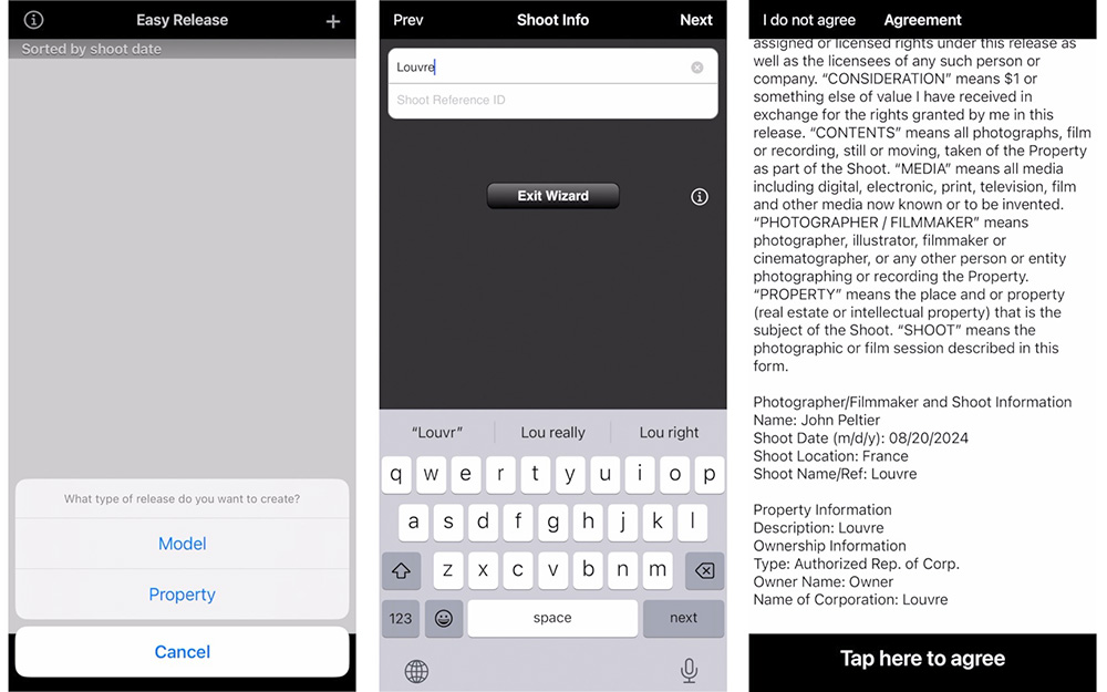
5. Easy Release
This photography app isn't so necessary for landscape photographers (unless you're photographing private property), but it is definitely a good thing for travel photographers to consider.
If you're going to be creating photos of strangers (or even people you know) or private property, you'll want to get a signed photo release just in case you want to sell that photo in the future. You can use Easy Release (iOS | Android) to do this; it has built-in standard release forms, or you can create your own.
I wasn't sure this electronic format was legally binding until I had to sign one for myself appearing in an NBC series. If it's good enough for network TV lawyers, it's good enough for you 🙂
Do you have a different favorite landscape photography app you'd like to share? Leave it below in the comments!


This is a great article! Thanks, John!
Thanks and you're welcome! I'll be sure to update it if anything else pops up later and welcome recommendations.