Disclosure: This post may contain affiliate links. I earn a small commission of product sales to keep this website going.
There are a number of great photography planning apps out there. For years, The Photographer’s Ephemeris (TPE) was the leader, offering several great useful features for photographers of all types. And then the PhotoPills app came along. How does PhotoPills compare to TPE? Has it made TPE obsolete?
What are PhotoPills and TPE good for?
These apps are planning tools.
At their most basic, they tell you when and where the sun and moon will rise and set. They also serve as a library for you to save your favorite shooting locations.
Knowing exactly when and where the sun will set behind a mountain, or what shadows will look like at a certain time of day, can be incredibly useful for landscape, documentary, and portrait photographers.
I strongly advocate for photographers to just “live in the moment,” as cliché as that sounds, but planning for light is also important. Of my five favorite photography apps, these are my favorite for planning the light.
A basic comparison of PhotoPills and TPE
Let’s look at some of the most basic user differences between PhotoPills and TPE first. We’ll dive into the specifics next.
Price
TPE is available for a one-time purchase price. It’s $9.99 for iOS and $2.99 for Android. The Android version has limited functionality (see below).
PhotoPills is also available for a one-time purchase price of $9.99 for both iOS and Android, with similar functionality on both platforms.
OS versions
PhotoPills has the exact same functionality for both iOS and Android.
TPE is available only in a limited version for Android with no add-ons. Features not available for the Android version that are available for iOS:
- Augmented Reality (AR)
- Night Mode (stars & Milky Way)
- Visual Search (find when sun or full moon will be rising/setting over a specific point, for example)
Learning curve
TPE is by far easier to learn because it’s a much simpler app.
Because it gives you fewer options, you’re likely to pick it up much faster. That doesn’t mean that some of its features are easy to use, I’ve just found it easier to learn.
PhotoPills is packed with so many features (useful ones, I’ll add) that you may find it overwhelming when you first start using it.
UI
PhotoPills is the sleeker app. TPE has been around for about ten years (released in 2009) and hasn’t really had any UI updates since then, just added features.
If you’re looking for “modern,” PhotoPills compared to TPE feels much more current.
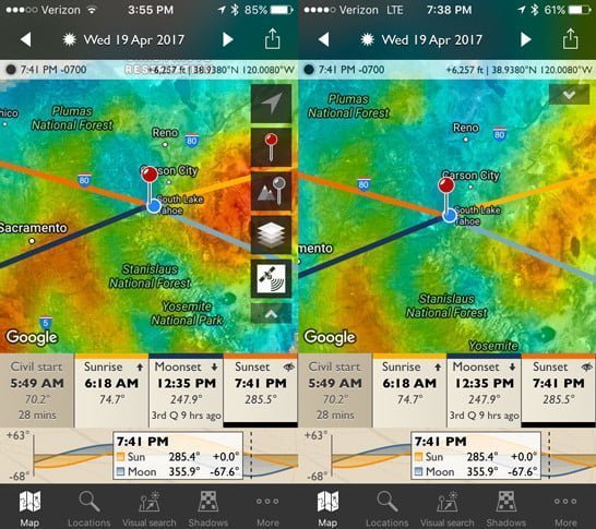
When you launch TPE you’ll be taken straight to the map showing the sun & moon data.
Opening PhotoPills will take you to a “menu screen” where you’ll navigate to the feature you want.
There’s also a sister app for TPE – TPE 3D, a “Google Earth”-type view showing what the terrain shadows will look like throughout the day. As much as I love this app, it’s incredibly clunky and difficult to use. But again, this is a completely separate app from the core TPE app.
Offline use
Going offline with TPE
The Photographer’s Ephemeris allows basic offline use, giving you a celestial almanac wherever you travel.
However, before traveling, you should pan & zoom the map to your travel area before going offline. This will download the map tiles & time zone data to your phone. Only the OpenCycleMap Topographic and OpenStreetMap can be downloaded for offline use.
Augmented Reality is available offline; Geodetics is not available offline. *Note Augmented Reality is not available for Android.
Read more about TPE offline use for Android and iOS from the developers.
Going offline with PhotoPills
PhotoPills also allows offline use, though the functionality is slightly more advanced than TPE. You can download any of the map types for offline use, but beware that this can take up more memory in the cache.
Plans are an additional feature of PhotoPills not found on TPE and these are available for offline use. We’ll go into more details about Plans in the next section.
Day and Night Augmented Reality is also available offline; Geodetics is not available offline.
Read more about using PhotoPills offline here.
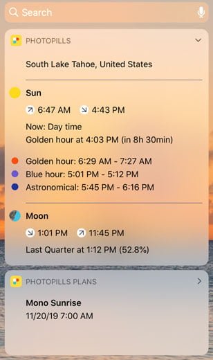
Widgets
PhotoPills has a Widgets feature for iOS. You can put some of the app functionality on your notifications screen to immediately see sunrise/sunset and sun/moon data without unlocking your phone.
Detailed comparison of PhotoPills and TPE features
| TPE | PhotoPills | |
|---|---|---|
| OS Availability | Android (limited) & iOS (full) | Android & iOS |
| Price | $2.99 (Android) $9.99 (iOS) | $9.99 |
| Ephemeris | Yes, offline | Yes, offline |
| Augmented Reality | Day and night, iOS only | Day and night |
| Geodetics | Yes | Yes |
| Light Pollution Map | Yes | No |
| Field of View Calculator | Separate iOS app purchase only ($8.99) | Yes |
| Sunrise & Sunset Quality | Subscription Add-On for iOS only | No |
| Save Plans | External to app | Within app |
| Exposure Calculator | No | Yes |
| Depth of Field Calculator | No | Yes |
| Time Lapse Calculator | No | Yes |
| Astrophotography Calculators | No | Yes |
| Drone Mode | No | Yes |
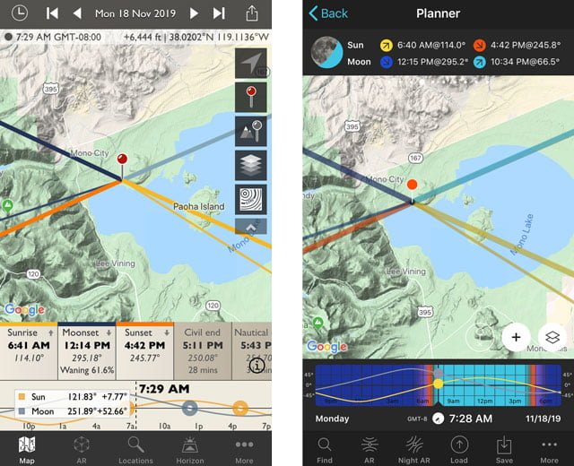
Ephemeris
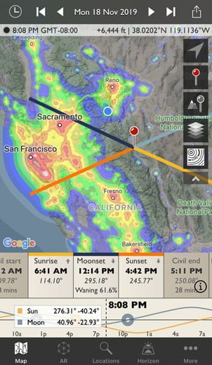
The ephemeris is at the core of both apps. An ephemeris is just a fancy way of saying it’ll show you where the sun and the moon are throughout the day.
In both apps, you can go to any point in the world, any date in the past or future (within reason), and see where the sun and moon will be transiting over a map. It will also show you the phase of the moon.
See times for sunset, sunrise, twilight, and golden hour.
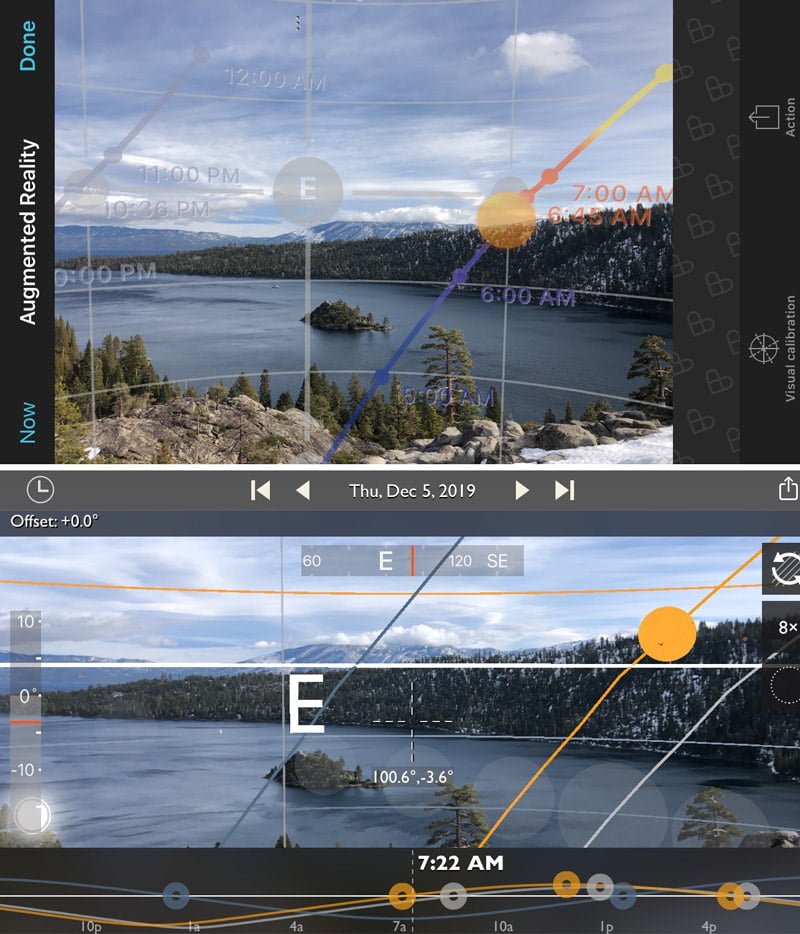
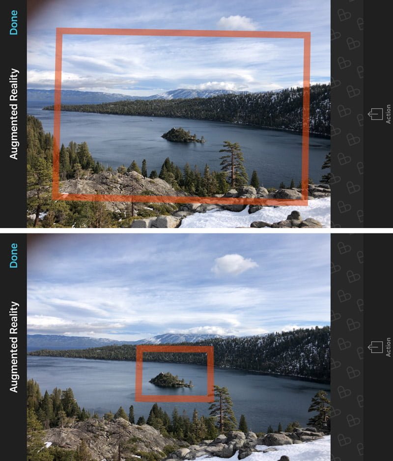
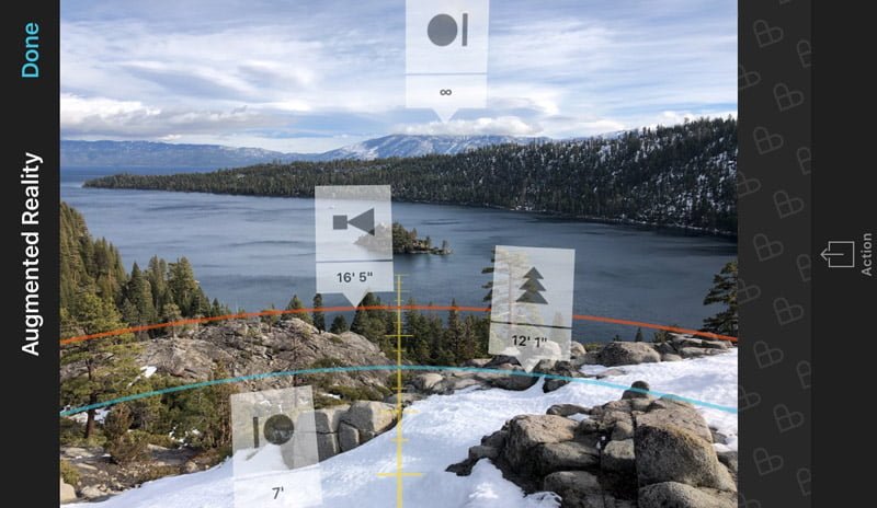
Augmented Reality
Both apps take the ephemeris to a new level with their Augmented Reality (AR) features. TPE, however, doesn’t have AR available on their Android platform.
The AR functionality allows you to look through the phone’s camera at the world in front of you and see where celestial bodies will be at any given time. Please note that the accuracy of the AR feature depends strongly on calibrating your device.
TPE displays everything in one AR display; as you scroll the time into night, the constellations and Milky Way appear on the screen. PhotoPills, however, has separate Day and Night AR displays. The PhotoPills Night AR feature only shows the Milky Way and path of stars rotation (no constellations).
PhotoPills also has AR modes available in the FoV and focusing features.
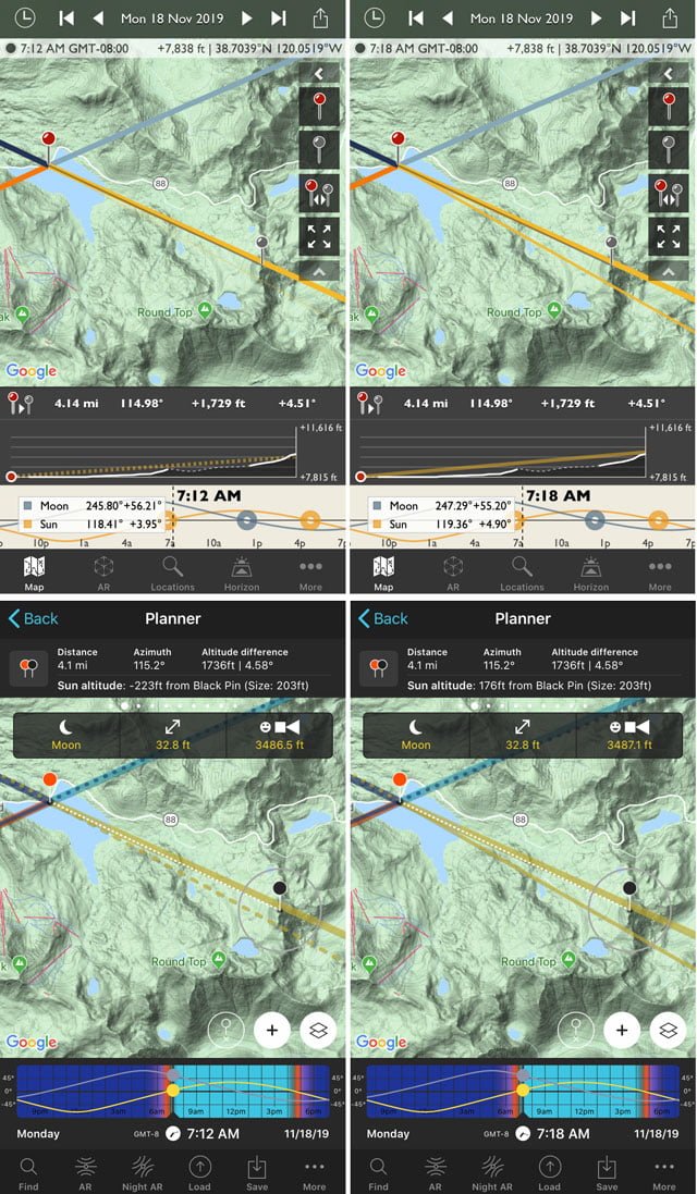
Geodetics
All of this ephemeris data would be good alone if the world was flat. But it’s not (according to those with at least half a brain). If sunrise is at 0725 but you’re at the base of a mountain, you won’t see the sun at 0725 – it could be hours until it rises over that mountain.
Geodetics uses digital elevation data to tell you line-of-sight information between to points of different elevations. A couple of years ago I wrote a post describing how to use geodetics with TPE.
So, say you’re standing on the top of one mountain peak looking at a different mountain peak. With both TPE and PhotoPills, you’d put a pin at your location and a pin at the other mountain peak. The app will tell you the azimuth (bearing) and angular information (degrees up/down) from one pin to another. Then it will tell you when the sun/moon/Milky Way will be hidden between those two points.
Geodetics in a comparison of PhotoPills and TPE are essentially the same, though I think TPE does a better job of displaying relevant information.
This feature isn’t available offline due to the massive amount of elevation data required for the calculations.
Light Pollution Map
The core TPE app has an overlay showing light pollution. This is useful in planning astrophotography – where the skies will be darkest and in which direction you might get light pollution. PhotoPills does not show any light pollution data.
Field-of-View Calculator
PhotoPills has a built-in FOV planning tool on the map. You input your camera, lens, focal length, and portrait/landscape orientation. Then you’ll see an overlay on the map that shows everything that will be in your frame with that field of view.
A separate FOV tool shows you the physical dimensions of your frame at your distance to the subject. You can go into an AR mode from this tool to see what your FoV will encompass in front of you.
The TPE folks also have a FOV calculator for iOS, but this is a separate app (The Photographer’s Transit, $8.99).
Sunrise & Sunset Quality
Just like the overlay for light pollution, TPE will also show an overlay of the expected sunrise & sunset quality for a forecast period of a few days. It takes into account the atmospheric conditions and will tell you where the amazing colors are likely to be. Skyfire is an added subscription to TPE.
I did a separate review of this a few years ago and determined that, while it’s a cool feature, it wasn’t worth the price. I don’t rely on sunsets & sunrises every day for my line of work, and it wasn’t accurate enough. Read my review of Skyfire here.
PhotoPills does not have any such functionality.
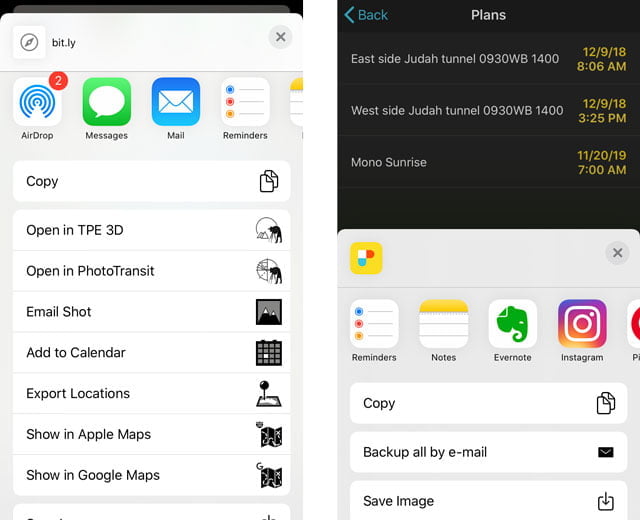
Save Plans
The ephemeris on TPE allows you to plan some spectacular shots. You can either write down those plans to remember them, or use the app to “Share” them to your calendar, map, notes, email, etc.
PhotoPills, however, allows you to save those plans within the app. The saved plans will show up in a “Plans” folder. You can also add the plans as Widgets in iOS for a quick at-a-glance reminder.
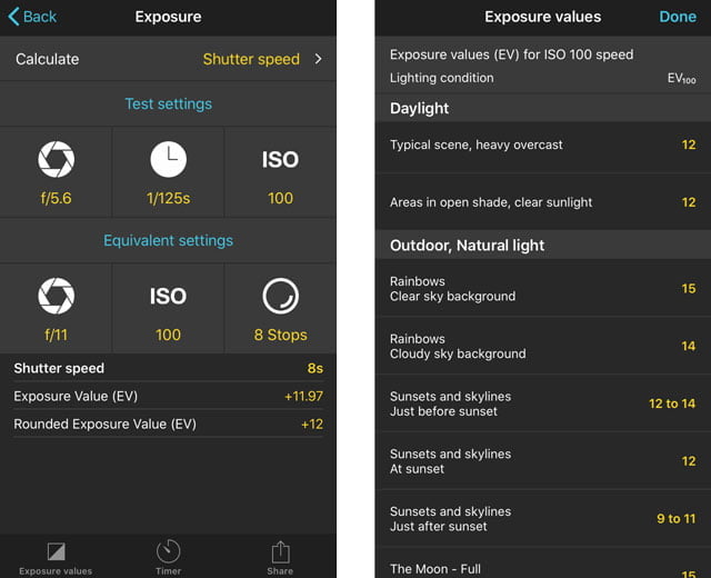
Long Exposure Calculator
TPE doesn’t have any exposure calculator tools.
PhotoPills has a “long exposure” calculator tool that will help you in planning long exposures. You’ll take a “normal” exposure without any neutral density filters in front of the lens. Enter those exposure values for ISO, aperture, and shutter. Then you can play around with different combinations of ND filter, ISO, aperture, and shutter to get the same exposure at longer shutter speeds.
Depth of Field Calculator
PhotoPills has some great focus-assist tools. TPE doesn’t have any of this functionality.
You’ll tell the app which camera and focal length you’re using. It can tell you which aperture and focus distance to use for the desired depth of field (range of focus), or it will tell you the depth of field based on an input focus distance and aperture.
This is useful when, for example, you’re photographing a group of people a few layers deep. Which maximum aperture could you use, and where would you focus, to ensure that everyone is in focus?
Focus information is also presented in a DoF Table and a Hyperfocal Distance Table. These tables have AR modes to help you see where to focus in the world in front of you.
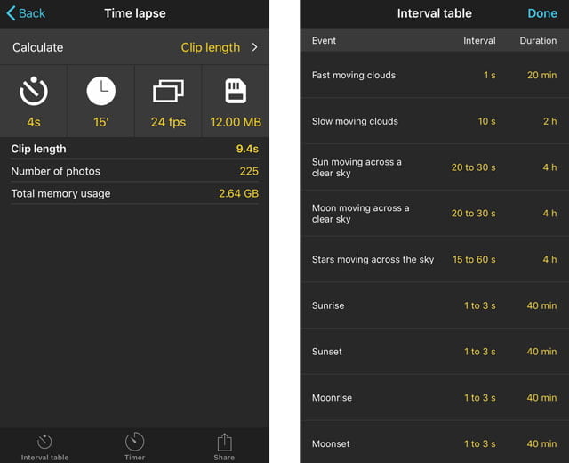
Time Lapse Calculator
PhotoPills has a useful time-lapse calculator for photographers who do that sort of thing. You can calculate for a shooting interval, final clip length, or total real-time duration. It’ll also tell you how many frames that will be and how much storage it will take. A supplementary table will give you recommended intervals and durations for certain situations.
TPE does not have a similar function.
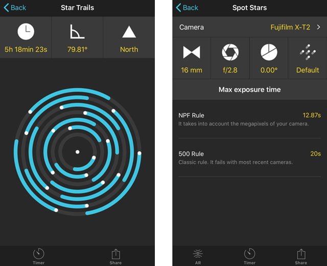
Astrophotography Calculators
PhotoPills is definitely useful for astrophotographers, minus the lack of a light pollution overlay and AR constellations, which only TPE has.
But there are three useful astrophotography tools in PhotoPills.
- A “Star Trails” calculator will show you how long star trails will be for a given exposure time.
- The “Spot Stars” calculator will tell you the maximum exposure time to avoid celestial movement at a given focal length, declination, and exposure time.
- The new release adds a “Meteor Shower” feature showing today’s meteor forecast, a forecast of major upcoming showers, and where to view.
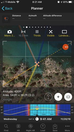
Drone Mode
PhotoPills has a semi-useful “Drone Mode.” You can see how much land is covered at different altitudes, but only while looking straight down. You can’t change the angle of the camera at all. I’ve only used it a couple of times, probably because “straight down” isn’t really my style.
Final thoughts on the comparison of PhotoPills and TPE
I can’t really say if PhotoPills is better than TPE. In fact, I use both for different things. It just depends on what your needs are.
If you’re just looking for a basic ephemeris to see when and where the sun will rise and set, and the occasional geodetics functionality, then I’d recommend The Photographer’s Ephemeris. It’s not cluttered with all those extra features which ultimately makes it easier to use and understand. Bigger isn’t always better.
However, PhotoPills is more of a “photographer’s suite” of tools for serious landscape photographers looking for an app that does everything, along with education and a social community – if you’re going to use it. It takes a little more dedication on the front end to learn all of the features.
PhotoPills and TPE are both fantastic apps, with their similarities and differences, and I hope this helped you make sense of it all.
When you’re ready, you can get the apps here:
Jeff Pratley
Tuesday 12th of July 2022
Thanks - very useful. For the last four or five years, I've been using timeanddate.com to learn the bearing of sun/moon rise/set and fiddling with Google Earth's measurement widget to establish the best position for shots. I've just installed PhotoPills and planned a trip to capture the moonrise behind a lighthouse tomorrow in seconds using my phone, rather than having to crank up my PC and do geometry to plan the trip. Special...
John Peltier
Wednesday 13th of July 2022
Yeah, it's quite an amazing capability. I hope it went well!
Tpe - The Photographer'S Ephemeris
Monday 14th of September 2020
[…] 8. PhotoPills vs The Photographer's Ephemeris (TPE) […]