LAANC For Recreational Use Airspace Authorization
Disclosure: This post may contain affiliate links. I earn a small commission of product sales to keep this website going.
There was some outrage in May when the FAA started enforcing new rules that said all drone pilots - recreational and commercial - must get airspace authorization before operating in controlled airspace near airports.
But there was no LAANC for recreational use. The system was only available to Part 107 certified pilots. There was no other system in place for recreational pilots to get airspace authorization near airports.
Well, LAANC is now available to recreational pilots also. How do you use LAANC for recreational use? Here's a basic outline.
I'll talk about Airmap and Aloft (formerly Kittyhawk) apps; this is not intended to be a comprehensive review of the apps, but rather instructions on how to get LAANC authorization. There are other ways to interface with LAANC but these are two that I'm familiar with.
NEW: As of June 2021, you'll also need to get a basic certificate to fly a drone recreationally. Read more here.
What is LAANC?
LAANC stands for Low Altitude Authorization and Notification Capability. It's a coordinated effort between the FAA and drone industry providers to allow pilots to get airspace authorization to fly in controlled airspace almost instantly.
Pilots of manned aircraft use flight plans and radios to communicate with air traffic controllers before entering controlled airspace. This is impractical for drone pilots because:
- The number of drone pilots making requests would overwhelm controllers.
- High-powered portable radios are expensive.
- Drone pilots on the ground would not have the line-of-sight necessary to reach many ATC facilities via radio.
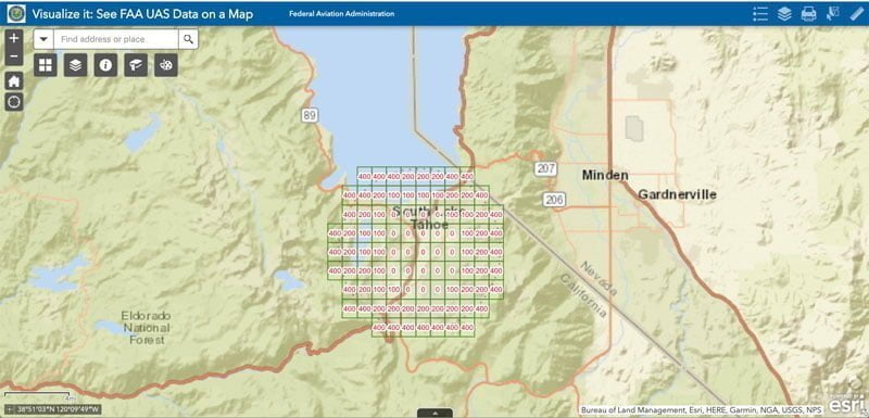
LAANC is an online database of airspace and temporary flight restrictions, updated in real-time. It's a three-dimensional model of small sectors near airports with maximum flight altitudes.
The FAA has determined that it's safe to grant instant airspace authorization to drone pilots below these altitudes; anything above requires extra coordination due to the potential for conflict with manned aircraft.
LAANC is not the same as DJI's Fly Safe Geofencing system. LAANC authorization will let you fly in some areas where geofencing will not, and geofencing will let you fly in some areas where LAANC will not. Do not assume that authorization in one system will keep you safe in the other.
The system is also not available at all airports yet. Click this link for the current list of FAA LAANC facilities. You'll need to get a manual approval if you wish to fly in an area that does not participate in LAANC.
When do I need airspace authorization with LAANC?
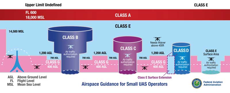
You need LAANC authorization to fly in any controlled airspace - Class B, Class C, Class D, and Class E Surface areas.
These areas generally encompass busier airports. The shapes and sizes of this airspace vary from airport to airport; there is no generic "five-mile" rule.
I'd recommend getting your Remote Pilot certificate, even if you don't plan on making money with your drone, just to have a better understanding of how the system works and when you need airspace authorization.
Getting instant LAANC authorization for recreational use
As mentioned earlier, there are a few different providers coordinating with the FAA to give instant LAANC authorization. This was only available to certified 107 pilots previously and is now available to recreational pilots also.
I've used Airmap and Kittyhawk (now Aloft), two publicly-available (and FREE) systems with Android and iOS apps. They both allow you to get instant authorization and apply for further coordination when outside of the "safe" zones.
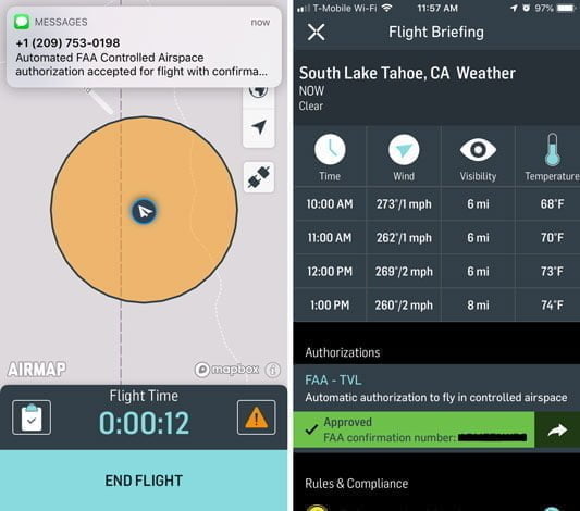
Airmap LAANC authorization
Download Airmap for Android | iOS
Of Aloft and Airmap, Airmap LAANC is the simplest to use.
Airmap will show you the maximum altitudes allowed for instant authorization.
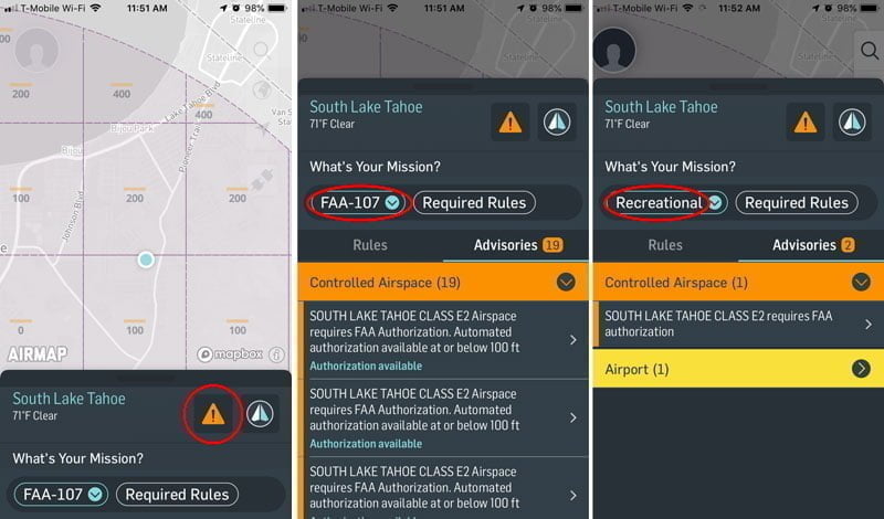
1 - Choose whether or not you're flying under FAA Part 107 or Recreational Pilot rules. Read the advisories that correspond to each rule by tapping on the warning icon.
2 - Create a flight plan for your flight once you read the advisories. Tap on the paper airplane icon. You can draw a simple circle, a flight path, or a polygon where you'll fly.
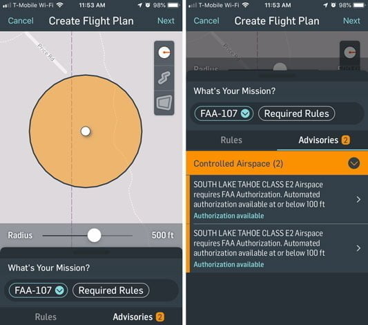
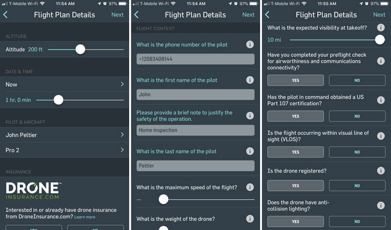
3 - Tap Next and fill in the details about your flight, such as:
- Your planned maximum altitude. To avoid getting your request denied, make sure it's at or below the maximum altitude indicated on the map and in the advisories.
- Date and time of the flight, as well as the planned duration of flight. You can only submit requests up to 90 days in advance.
- Provide your name, phone number, and a justification for the flight. You don't need a justification justification, just what you're doing. Like "landscape photography" or "home inspection."
4 - Tap Next after you fill out all the details. You'll get a weather report and a final button to submit the request.
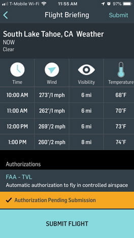
5 - Almost immediately after clicking "Submit Flight" you'll get a text message about your airspace authorization with a confirmation number.
Aloft LAANC authorization

Download Aloft for Android | iOS
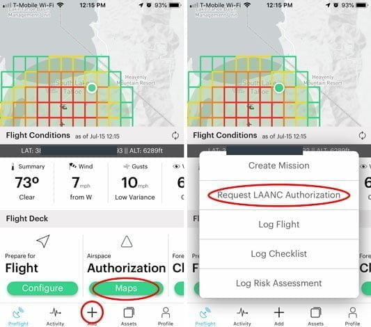
Aloft (formerly Kittyhawk) has a lot more features within the app, which may or may not be what you want. They can clutter it up more, but they do give you more of a total suite. It includes weather, broadcasting options, nearby drone traffic, checklists, and more.
1 - The map is color-coded to show you how high you can get instant authorization for, red being 0 and green being 400. You can request authorization by tapping Authorization Maps or the "Add" Request LAANC Authorization.
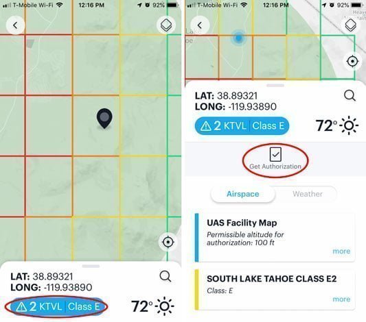
2 - Move the pin to the general area you want to fly. You'll have an opportunity to set your flight area in the next step. Once you have the pin in the right location, tap on the informational button at the bottom to pull up the advisories. Tap "Get Authorization" once you understand the advisories.
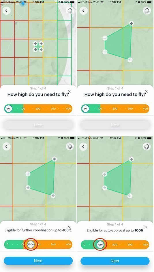
3 - Draw your flight area using the corner icons. Once you have your polygon set, adjust the maximum flight altitude you're requesting. If it's above the maximum approved altitude you'll get a notice that you're only eligible for manual approval. Otherwise, if it's below the maximum ceiling, you'll get a notice saying you're eligible for auto-approval. Tap Next when you're ready.
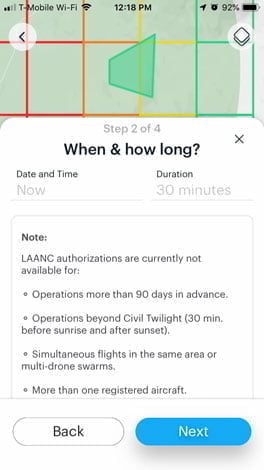
4 - Enter the date & time you're requesting the airspace authorization and your anticipated flight time. Then tap Next.
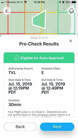
5 - The system will check that your area, altitude, and date will be approved. Review the information and tap Next.
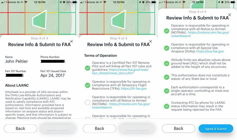
6 - The final step will require you to manually verify the rules before submitting to the FAA. Part 107 pilots will need to input their certificate number in their profile. Once you check all the circles, "Agree and Submit" will appear at the bottom.
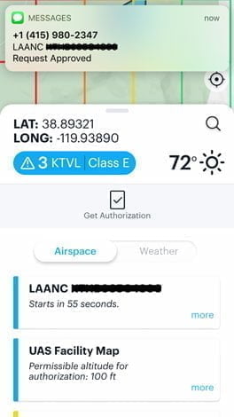
7 - After tapping Submit you'll get near-instant approval. A text message contains your authorization number, which will also show on the next screen in Aloft.
Important: Don't forget to unlock DJI Geofencing
You're not done yet!
LAANC for recreational use gets your authorization with the FAA only.
DJI will still lock you out of some of these areas with their geofencing system.
You'll need to unlock DJI's geofencing system after you get a LAANC airspace authorization. Read this post to expand more on that, to determine if you're in restricted or authorization zones and how to unlock geofencing.
Fly safe!
This is a big win for recreational pilots, but it comes with a lot of responsibility.
The FAA now knows who is flying a drone in controlled airspace and when. Don't feel like they're singling you out; this has been true for manned aircraft for decades. It's nothing "against drones," they're just trying to apply the same standards for all operations in the national airspace system.
Great article!
Thanks Chris, I'm looking forward to seeing how Kittyhawk continues to evolve!