Disclosure: This post may contain affiliate links. I earn a small commission of product sales to keep this website going.
You know that saying, right? One person poops their pants and now we all have to wear diapers? That’s why DJI will lock you out of flying in certain areas without going through authorization processes (thanks guys!). It’s important for drone pilots to understand how to use the DJI Fly Safe geofencing system and how to unlock it.
Background on geofencing
Geofencing has been around in one form or another for years. It started as a basic two-dimensional circle around certain airports that would prevent flight. It was a basic solution but was overly restrictive.
GEO 2.0 was introduced in late 2018 in response to both additional drone incidents and lobbying by pilots to allow flight in previously restricted areas. A compromise was made between those two factors. DJI actually took a major lead in this, working with the FAA and multiple professional flying organizations to come up with the best solution possible for both pilots and public safety.
This enhanced version of geofencing not only improves on the two-dimensional model but also adds a vertical element. The new model is based on the International Civil Aviation Organization’s (ICAO) standard for airport safety zones.
GEO 2.0 was recently added to European airports following the major London disruptions around Christmas 2018.
DJI’s Fly Safe geofencing map will not show you restrictions for flying in controlled airspace (yet). The FAA enacted changes in mid-May 2019 that prohibit recreational drone pilots from flying in controlled airspace – read more here. Update: Authorization with the LAANC system will be available to recreational pilots starting July 23 2019.
How DJI Fly Safe geofencing works
Geofencing has a massive database of three-dimensional areas all over the United States and Europe where flight is restricted in one form or another. These areas include airports, prisons, power plants, and other sensitive areas.
DJI Fly Safe no-fly zones are broken down into Authorization zones, Restricted zones, Altitude zones, and Enhanced Warning zones. Each of these zones has different rules (explained later).
Your drone will not take off if you start your flight in one of these areas without special action. If you are already in flight and hit one of these boundaries, your drone will stop in mid-air like hitting an imaginary wall. And then it will auto-land without any regard to what’s below it. Look out!
Types of geofencing
DJI’s geofencing breaks up airports into High Risk, Medium Risk, and Low Risk.
This is based on the volume of air traffic and passengers in & out of that airport. As you can imagine, high-risk airports are more restrictive than low risk.
Looking at the zones below, you can see how these areas differ between airports.
Don’t fret about the lateral dimensions, it’s more important to understand what each zone means.
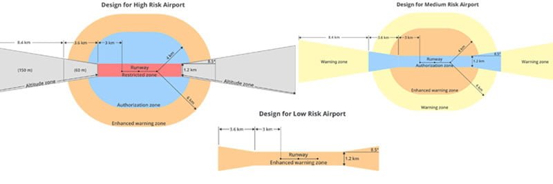
Restricted Zone (red): Runways and sensitive areas like prisons & power plants. No Flight.
Altitude Zone (gray): Approach path at high-risk airports. No Flight above a certain altitude (imagine a plane coming in to land or taking off). You may fly up to 150m (FAA regulations permitting) in the area of the bowtie further from the airport; closer to the airport you may only fly up to 60m.
Authorization Zone (blue): Areas around high-risk airports and runways at medium-risk airports. Restricted by default but users can self-unlock (explained later). For most of us, blue areas are the only ones we need to plan for in the DJI Fly Safe system.
Enhanced Warning Zone (orange): Areas around high and medium-risk airports, and runways at low-risk airports. You only have to acknowledge through the app that you understand it’s a warning area before you fly – no internet connection or verified account required.
Warning Zone (yellow): Informational message in the app that you’re in a warning area. No special action required.
Example geofencing
I don’t have a lot of restrictions near where I live, so let’s head a few hours west to San Francisco. This is what the DJI geofencing map from the DJI GEO website looks like (the DJI GO 4 app mirrors this). You can click/tap on any of these areas to find out what they are. I’ve added these descriptions my own to illustrate everything you’d see.
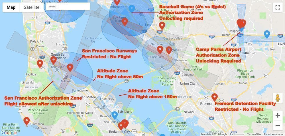
You should always check the geofencing restrictions before a flight. Even if you think you’re not near one of those zones, a Temporary Flight Restriction (TFR) could have popped up without you knowing it (like a baseball game).
Check the current DJI geofencing map restrictions at dji.com/flysafe/geo-map.
Alternatively, you can also check geofencing through the DJI GO 4 app. Go to the main menu in the startup screen and select “GEO Zones.”
Unlocking DJI Geofencing
So you’ve checked the geofencing restrictions and found that you want to fly in one of these zones. How do you unlock geofencing? That depends on who you are and where you want to fly.
Self Unlocking
The self unlock applies to most of us who want to and have good reason to fly in an Authorization Zone (blue). You’ll still need separate ATC clearance if required for your operation.
1) Verify your account
Just to make sure big brother knows who you are. You need to supply a credit/debit card or mobile phone number. DJI doesn’t store this information; it’s just for identity verification. You’re not gonna do anything wrong so there’s nothing to worry about, right?
2A) Real-time through the DJI GO 4 App
You can unlock geofencing through the DJI GO 4 App once you’re connected to your drone and attempting to fly in an Authorization Zone. This is called Live Self-Unlocking. It’s nearly instantaneous, but it does require an internet connection. The authorization is good for 24 hours.
2B) Unlocking ahead of time
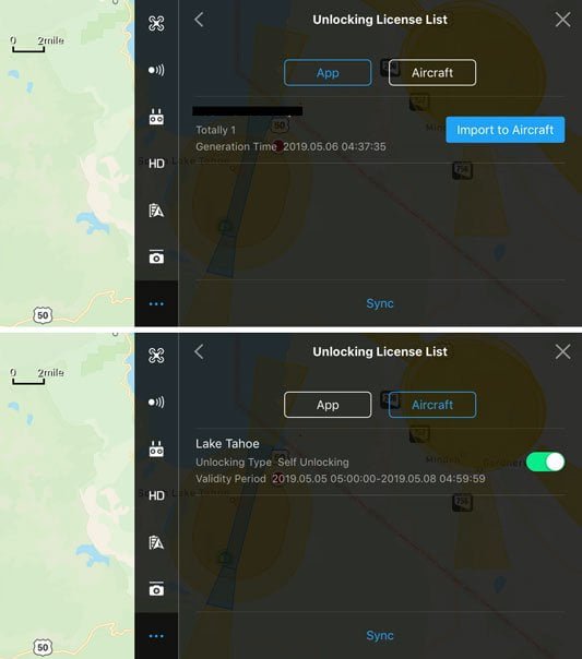
You can schedule up to 30 simultaneous authorizations from the web. You’ll need to do this if there’s any doubt about having an internet connection in your flight area. Go to DJI’s Self-Unlocking page to schedule these. They’re good for three days after the scheduled start – ideal for situations where you’ll be out of service for a while. Don’t forget to download your license to the app before you go off the grid! You can find the licenses under Unlocking List in General Settings.
Custom Unlocking
Custom unlocking is for users who have authorization to fly in a restricted area, like an airport runway or power plant. This would be for first responders or power plant inspectors.
You need to submit special paperwork and this won’t be discussed further here.
Geofencing doesn’t include all restrictions
This is one of the critical steps of planning an aerial photography shoot.
Be mindful that the DJI geofencing map doesn’t include all restrictions. State parks, national parks, Wilderness, monuments, etc., for the most part aren’t on here.
It also doesn’t display airspace classes, which restrict pilots from flying. It’s ultimately up to you to check. Other apps like Drone Buddy include some of these areas but not all.
Please leave any questions or comments that you may have about geofencing below.
Steven Wisenbaugh
Friday 24th of December 2021
I have FAA clearance but DJI still will not unlock my craft.
Michael
Wednesday 8th of January 2020
So, Is this needed as well as say Kittyhawk? Do you need both or one other the other? Need some clarification. Thanks
John Peltier
Wednesday 8th of January 2020
Yeah, unfortunately, you need to do both as of now. You need to get your legal ATC clearance from the FAA using Kittyhawk to fly in controlled airspace, then unlock DJI Authorization Zones once you've received clearance. The FAA did approved DJI as a LAANC provider in late 2018, but it's currently not available to most pilots. Hopefully, this capability opens to everyone sometime soon so you can just do it all in the DJI app.
David Rij
Monday 9th of September 2019
Here's a problem I ran into when flying in unrestricted Class G airspace and getting the NFZ warning that prevented me from flying, after you obtain all those unlocks so you can fly in controlled airspace where the FAA already allows you to fly, don't forget to turn off every single unlock license when you don't need them otherwise you get a NFZ warning. So all the unlock licenses have to be turned off to fly elsewhere, even in uncontrolled airspace, otherwise you will not be able to fly.