Disclosure: This post may contain affiliate links. I earn a small commission of product sales to keep this website going.
Backpacking the High Sierra Trail
Most people complete their High Sierra Trail itinerary in 6-8 days. The official trail length is 61.5 miles from Crescent Meadow to Mt. Whitney, but getting to Whitney Portal makes the total hike length 72.2 miles.
There are enough campsites along the High Sierra Trail to more or less split up your backpacking trip among even mileages, but there are a few considerations:
- It’s always nice to be near a water source
- Don’t wear yourself out the day before the Whitney summit
- And don’t overdo it on the first day out either
- Will you be sheltered from a storm?
- Where will you go if there are no more campsites left at that location?
- Does that campsite have enough room for your group?
- And, of course, what is the scenic quality of the campsite?
With all of that in mind, this is my recommended High Sierra Trail itinerary. This was also our actual seven-night itinerary and it worked out great. It was a nice leisurely pace that we all enjoyed.
Also, remember that there are trail quotas. So when I say “large campsite”, that doesn’t mean that we were surrounded by dozens of other campers. The closer we got to Whitney the more the campsites filled up, but for the better part of the trail we never shared these sites with more than ten other campers.
For more on the High Sierra Trail, including getting permits, read High Sierra Trail Trip Report
Click on the maps to open them in Gaia GPS and download the GPX files.
High Sierra Trail Itinerary
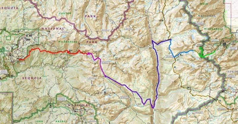
Day One: Crescent Meadow to Nine Mile Creek – 8.8 miles, 1,410′ ascent
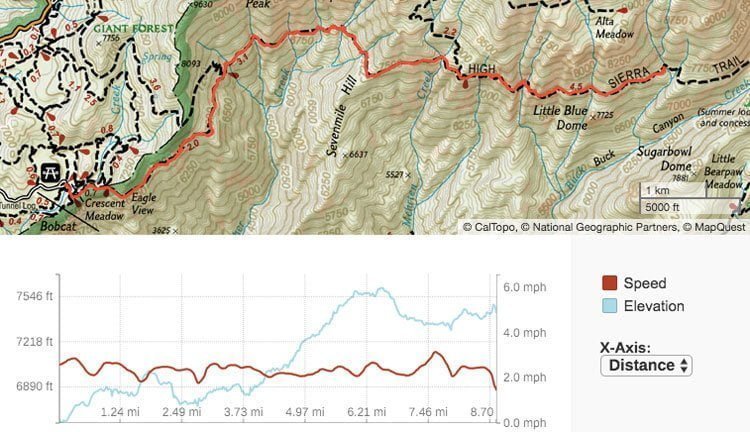
Start the hike at Crescent Meadow and backpack to Nine Mile Creek. You’ll be on the south-facing side of the valley in which the Middle Fork of the Kaweah River runs through. Much of the trail is shaded, but it can still get very hot due to its south-facing aspect.
The first three miles are fairly dry, but there are numerous spring and creek crossings over the final six miles. You’ll enjoy great views of Sugarbowl Dome, Little Blue Dome, and Castle Rocks.
Nine Mile Creek campsite: There are a couple of sites near the bear box right on the trail. Another hidden spot lies to the north of the trail, and there are a couple other spots down the hill to the south. Nine Mile Creek is immediately east of the campsite and offers a few semi-secluded swimming holes. This campsite is very wooded and can get buggy.
Alternate campsites:
- Mehrten Creek: ~6 miles, about a half-dozen sites, bear box, water, slightly exposed, views.
- Buck Creek: ~9 miles, only a few sites, bear box, water, slightly exposed, in a scenic canyon.
- Bearpaw Meadow: 11.4 miles, numerous sites, small spring, wooded with nearby great views.

Swimming hole at Nine Mile Creek
Day Two: Nine Mile Creek to Hamilton Lake – 6.9 miles, 1,760′ ascent
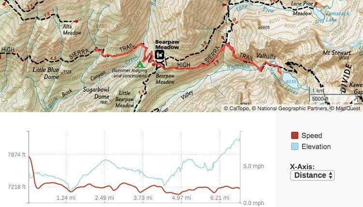
From Nine Mile Creek you’ll immediately descend down into Buck Canyon, where you can find some backup campsites if Nine Mile is full. Then you’ll climb out of the canyon and hit Bearpaw Meadow, which is another common first-night campsite. You’re now on the south face of another valley, this one surrounding Hamilton Creek. This trail is also exposed and can get hot; an early departure is recommended. The final climb from the waterfalls up to Hamilton Lake can exhaust many people.
Thanks to Matt for the update that the trail out of Hamilton Lakes may be unpassable now, requiring a detour over Black Rock Pass from Bearpaw Meadow. Check with the ranger for current conditions.
Big Hamilton Lake campsite: There are numerous campsites spread out along the northwest side of the lake, which is backdropped by gorgeous granite cliffs and two waterfalls. Be sure to check in the crags south of the big granite slab; there are a few other sites back here. There are two bear boxes at Hamilton Lake and also a pit toilet. The pit toilet is more or less useless and overflowing as of July 2018. No campfires.
Alternate campsite:
- Precipice Lake: ~9.9 miles, 3,760′ ascent, a few exposed sites, above the treeline, spectacular views. Only attempt to continue here if it’s not too hot and you’ve got plenty of juice left. This very unique lake has a few sites on the west and north side. No campfires.

Dinner at Hamilton Lake
Day Three: Hamilton Lake to Big Arroyo Junction – 7.9 miles, 2,570′ ascent
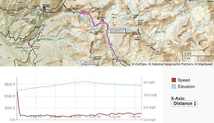
The climb out of Hamilton Lake is best done early in the morning before the sun hits the north wall; this’ll keep it cooler and is also beautiful. You’ll soon find yourself above the rock formation known as Valhalla (which you were staring at from below the previous day). There are some great wildflower shows and numerous creeks during the climb out. This section of the High Sierra Trail also features the tunnel that was blasted through the canyon wall after a steel bridge was destroyed in 1937. You’ll reach Precipice Lake, cross over Kaweah Gap and the Great Western Divide, then descend the Nine Lakes Basin to Big Arroyo Junction. There are plenty of water sources after the pass.
Big Arroyo Junction campsite: This campsite has numerous spots near Big Arroyo Creek; they’re all spread out and most provide shelter. There is one bear box here. This was one of the worst mosquito experiences of the trip but there aren’t a lot of other options.
Alternate campsites: There is one campsite suitable for a couple tents about a half-mile prior to reaching Big Arroyo Junction; you’ll see this on the right side. Near a small creek and sheltered in woods.
- Moraine Lake: ~14.7 miles, 3,790′ ascent, sheltered, scenic lake. Long hike topped off by an exposed final section that can get hot while climbing up to the Chagoopa Plateau.

Camping at Big Arroyo Junction
Day Four: Big Arroyo Junction to Kern Hot Springs – 13.9 miles, 1,250′ ascent (3,900′ descent)
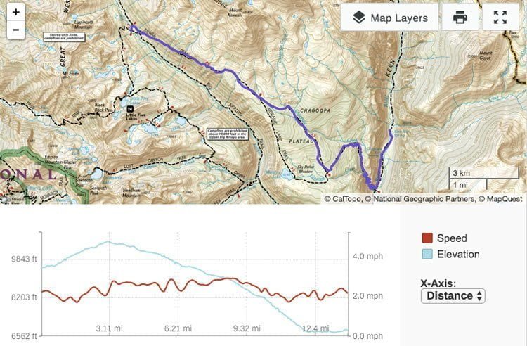
The climb out of Big Arroyo Junction is a pleasing, long, steady 1,000′ ascent to the Chagoopa Plateau. The descent takes you back down this scenic plateau; at almost five miles you can take a detour to Moraine Lake or continue north around the lake to Kern Canyon. The plateau rapidly starts to drop off approaching the canyon and in no time you’ll be descending almost 4,000′ from the highest point of the plateau. From the bottom of the trail, it’s two miles through shale and riparian forest to Kern Hot Springs.
Kern Hot Springs campsite: This is one of the largest campsites along the High Sierra Trail. The northernmost spots have water access at Rock Creek, the rest are better off getting water from the Kern River. There is also a hot spring at this site, as the name implies. Use the concrete tub that fills from the smaller hot spring above. It’s next to Kern River. Going between the cold river water and hot spring water will recharge your tired feet. There are two bear boxes at Kern Hot Springs and one newer pit toilet in excellent condition (it’s really just a wooden platform over a hole in the ground with a toilet seat, and a waist-high wooden fence for privacy).
Alternate campsites:
- Moraine Lake: ~7.3 miles, 1,100′ ascent, water, scenic lake, wooded.
- Upper Funston Meadow: ~12 miles, water, wooded, buggy.

Kern Hot Springs
Day Five: Kern Springs to Wallace Creek – 12.4 miles, 3,600′ ascent
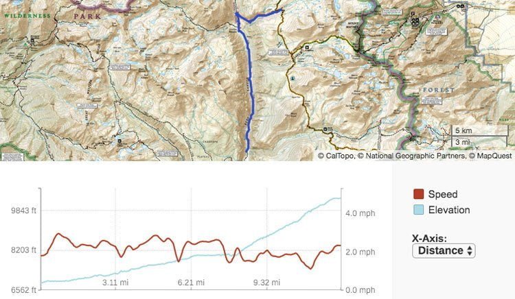
Despite being shorter than the previous day, this day will feel longer thanks to the altitude gain. The first eight miles are shaded and scenic as the High Sierra Trail gradually climbs along the Kern River and bottom of Kern Canyon. There are numerous stream crossings, some of which can be quite tricky and may require changing footwear if you brought it. Upon reaching Junction Meadow, the trail quickly climbs out of the canyon and up Wallace Creek. You’ll get some great views down Kern Canyon to the south, and the Kaweah Peaks and Kern Kaweah River Falls to the west.
If you camp at Kern Hot Springs, Wallace Creek is probably the best place to stay for an easy half-day to Guitar Lake. If you camp at Junction Meadow this night or the next, you may want to skip Wallace Creek and proceed to Crabtree Meadow the following night.
Wallace Creek campsite: The High Sierra Trail joins up with both the Pacific Crest Trail and John Muir Trail at Wallace Creek. This means that the established campsites can quickly fill up, especially if you get there late. There are still, however, plenty of sites spread out throughout the area. There is one bear box and easy water access. The campsite is semi-wooded but the high elevation can make some sites exposed. No campfires.
Alternate campsites:
- Junction Meadow: 7.7 miles, 1,100′ ascent, water, wooded, bear box, buggy.
- Crabtree Meadow: 16.4 miles, 4,200′ ascent, water, wooded, ranger station. No campfires.

Campsite at Wallace Creek
Day Six: Wallace Creek to Guitar Lake – 6.8 miles, 1,530′ ascent
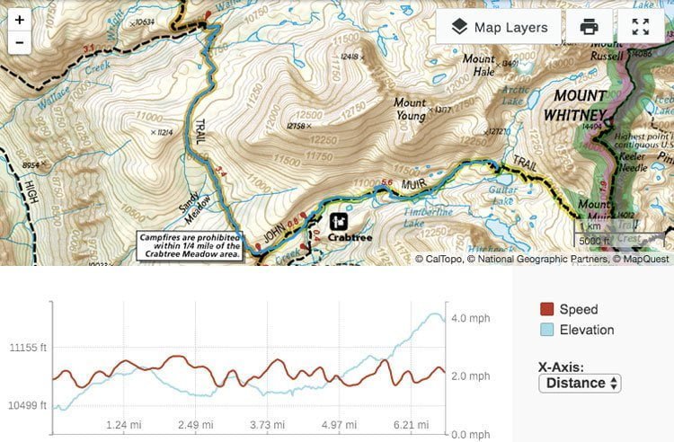
The hike from Wallace Creek to Guitar Lake is a simple 6.8-mile jaunt, a nice break from the past couple days of 12-13 miles and tall ascents. You’ll leave Wallace Creek, get some final views of the Kaweahs, hike past scenic Sandy Meadow, and arrive at Crabtree Meadow. Grab a wag bag at the trail junction if you don’t have one and continue past Timberline Lake to Guitar Lake.

Surprise thunderstorm at Guitar Lake
Guitar Lake campsite: Guitar Lake is at 11,500′ and very exposed. There are numerous spots in the rock field on the northwest side of the lake, and a few more on the plateau on the north side of the lake, across the creek. Plenty of marmots will be waiting for you to step away from an open bear canister. There are a couple of large boulders for privacy when you need to relieve yourself. No campfires.
Day Seven: Guitar Lake to Outpost Camp – 11.8 miles, 3,100′ ascent, 4,200′ descent
Note: I couldn’t get a GPS signal until about a mile up the hill, so this track is missing that first section.
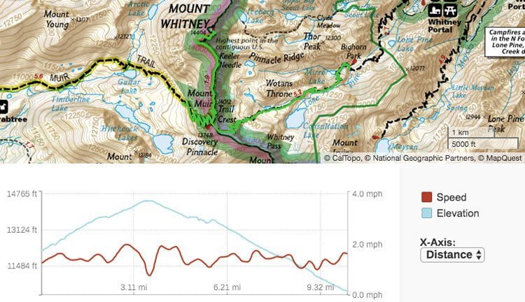
This is a long day that most backpackers start early, usually around 2-3am. Both times I’ve done this I started at 2am and arrived at the summit of Mt. Whitney for sunrise. Another advantage of starting early is that you’ll avoid the early afternoon thunderstorms that can often develop in the summer and ruin your hike. Leave your packs at the trail junction for Trail Crest and make the final push with only some water, food, and a camera. After summiting Mt. Whitney, head back down to Trail Crest, grab your pack, and descend down the 99 switchbacks. You’ll be staring at Trail Camp all the way down these switchbacks; this camp is a cesspool in my opinion, often flooded, exposed, smelling like urine, and littered with used wag bags and other trash.
Outpost Camp campsite: This is also a crowded campsite, but it’s much cleaner than Trail Camp. People seem to respect this site more. It’s next to a creek and a large waterfall, and below the treeline. No campfires.
Alternate campsites:
- Trail Camp: 8.8 miles, exposed, water access, very crowded, trash, no campfires.
- Lone Pine Lake: ~12.7 miles, few campsites, water, scenic, no campfires.
- Whitney Portal: 15.5 miles, partially wooded, camp store, bathrooms, walk-in only.

Outpost Camp
Day Eight: Outpost Camp to Whitney Portal – 3.6 miles, 2,150′ descent
The final day is capped off by a short descent to Whitney Portal, where there are burgers and beer waiting at the store.
Read my High Sierra Trail Planning post for information on transportation to Lone Pine from Whitney Portal.
Richard
Thursday 6th of January 2022
Outstanding review of HST and lite backpacking, thank you for writing it up. Planning the trip for August 2022.
John Peltier
Friday 7th of January 2022
That's awesome, have fun! Might be big snow year, so expect some lingering into August. And I know there were some changes to the trail after I did it due to landslides so be sure to check with the NPS about that.
Kasey
Thursday 27th of May 2021
How reliable is the walk up permits?
John Peltier
Friday 28th of May 2021
If you're there in the morning when the office opens, I don't anticipate you should have any problems (but I can't guarantee it). You don't need to get there at 4am to make sure you're the first, just get there around opening. When it's not reliable is when people show up late in the day expecting to get a permit.
Maria
Monday 8th of March 2021
Hi John, thanks for sharing this resource. It’s what I’m going to use for my trip this yr (2021) end of August early Sept. I am however adding a couple more days so the trip will be done between 9 to 10 days. Where do you suggest that we stretch it out a bit? I was thinking somewhere between Kern Hot Springs and crab Meadow or maybe between big Arroyo Junction and Karen Springs. Or maybe elsewhere? What do you suggest ?? Thanks for your input.
John Peltier
Tuesday 9th of March 2021
You can explore around Moraine Lake. I don’t think there’s much between Kern Hot Springs and Crabtree Meadows until the end when you meet up with the PCT; instead of leaving Kern Canyon up Wallace Creek you could go up Tyndall Creek. That’ll add another day at least.
Ta
Monday 8th of March 2021
I got my permit today -March 8, 2021- and have the same question: I have an extra day at Moraine Lake but if I wanted to go on without that extra night is there camping between Kern Hot Springs and Wallace Creek? Is the itinerary flexible at all? Thanks.
A Diary from 2019: the Story that was left Unsaid – Trailing Ahead
Sunday 29th of November 2020
[…] decided to pursue in future. A rather nice guide to do the entire trail over a week is available on this website. The trail offers a balcony view of the High Sierra up […]
shelly l williams
Monday 2nd of September 2019
Hello John, My son and friend both 20 are headed out from Visalia on Sept. 10th and we just realized the shuttle stops on Sept. 8th. We are trying to find transportation to crescent valley trailhead. Do you have any suggestions? We are trying to plan from the east coast and are not finding any solutions....thanks in advance for any help. Best, Shelly
John Peltier
Monday 2nd of September 2019
Oh no! You're probably finding as much information as I would be able to. Unfortunately I don't have any "locals knowledge" about unlisted transportation to Crescent Meadow. Rideshare is going to be expensive but maybe not too bad split between three people. There's always hitchhiking :) I hope you get it worked out!