My New Favorite Phone GPS Backpacking & Hiking App
Disclosure: This post may contain affiliate links. I earn a small commission of product sales to keep this website going.
 It seems I've been on a search for one good, multi-use hiking app for a long time. I've been through them all, and Gaia GPS is the one I've stuck with for the longest amount of time. It seems I'm always finding more uses for it.
This is an unsolicited, unpaid review of Gaia GPS.
Rundown of Gaia GPS subscriptions & features
Gaia GPS - Free app download
You can download the app for free (iOS | Android) but you are limited to the Gaia Topo maps. You won't be able to download the maps for offline use.
Gaia GPS - Base Membership $19.99 per year
Many hikers love CalTopo. Gaia GPS includes CalTopo maps. Some of the other maps available to you are:
- National Park Service maps
- USFS & USGS Topographic maps
- OpenCycle, OpenHiking, & OpenStreet maps
- MapQuest & USGS aerial imagery
- NOAA boating charts
- Aviation IFR & VFR charts
And what can you do with these maps?
- Create preplanned routes
- Print maps with grids and overlays
- Download publicly-shared routes & share your own routes
- Save maps to your phone for offline use
- See every statistic you could think of for your hike
- Photographers can sync their photos to GPS tracks
The great thing about the Gaia hiking app is that it's cloud-based. You don't need computer software or cables, just the app. It'll work on any Android & iOS device.
You can find routes or create your own on your computer, and they're automatically transferred to your phone. Any tracks that you record with your phone will be available on your computer.
One other thing I've noticed about Gaia, compared to some other hiking apps, is how smooth it is. The map is totally smooth while you pan it, and doesn't blink as it does on some other apps.
Gaia is very intuitive and easy to use. Creating waypoints and tracks is easy, you can quickly switch between UTM & Lat/Long, and data is easily saved & organized.
Need more info than just a map? Gaia will also show you the weather forecast, show a radar overlay for storms, and give you the tides.


Gaia GPS - Premium Member subscription
- $5.99 per month
- $39.99 per year (40% discount over monthly)
Additional maps available for subscribers:
- NatGeo Trails Illustrated Maps (over 250 maps)
- NatGeo John Muir Trail & Appalachian Trail Topographic Map Guides
- MapBox Aerial, MapBox Outdoors, MapBox Streets
- A number of international maps
- NeoTreks Premium Land Use Maps
Extra features for Gaia Premium subscribers:
- Stack maps and adjust the opacity. For example, see a satellite photo on top of a USFS map.
- Create geometric areas and calculate their size.
- See land-use designations, such as public land, private land, hunting zones, etc.
Using Gaia on a smartphone
All screenshots here are from the iPhone SE. Other phones and tablets will be slightly different.
Let's look at the main map first. In this grab, I have the MapBox Aerial at 75% opacity with a USGS Topo as the base map, overlaid with a recorded track. You can control which maps and overlays you see in the menu accessed by the upper right corner of the app.
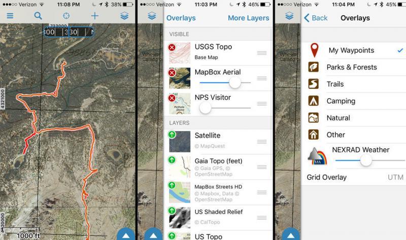
Much more is available when you go to the main menu, accessed in the upper left of the app. You can:
- see trip statistics
- check out the current and forecasted weather
- look at tides for coastal areas
- load/edit other routes, tracks, or waypoints
- get driving directions to the trail with your phone's default navigation app
- export the track to GPX or other files compatible with different computer programs
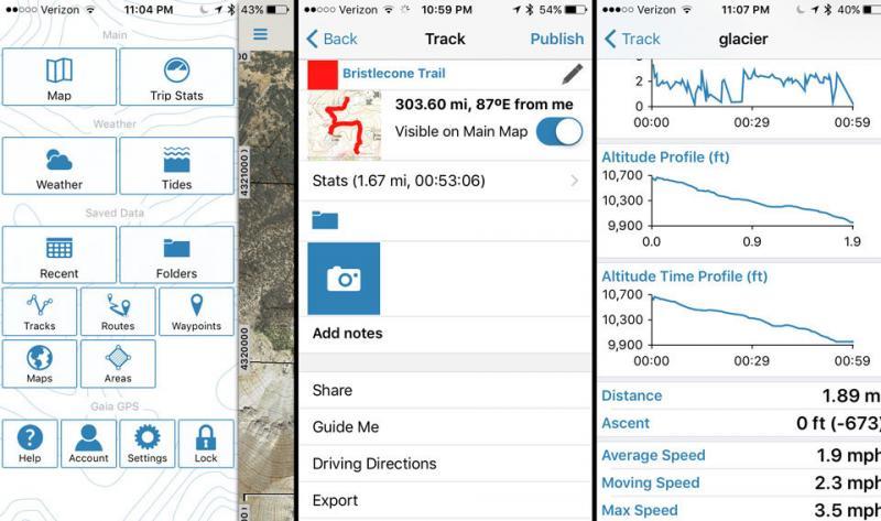
I've minimized it in these screenshots because it shows my current location (eek!), but there are a few buttons at the bottom of the map screen. A Record button will initiate recording of a track, and a Camera button will access your camera to take a geotagged photo.
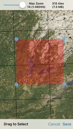
You can download maps to your phone by going to the Download Maps option in the Maps menu screen. Adjust the corners of the map and tell it which type of map you want! You can see how much space this will take on your phone in the upper right.
Using Gaia on the web
As mentioned earlier, the Gaia app and Gaia website are connected via the cloud.
Let's look at this example.
Say I wanted to go backpacking to Star Lake. I go to gaiagps.com and pan to Star Lake, then turn on the Public Trips overlay. I can draw it on the map if no one has saved that route before, and it's saved to my phone. If someone has shared this route, I can click on it to see information on the hike. Then I can save it to my phone if I want to use it. Here we see a Gaia user has already shared this route, so let's check it out.
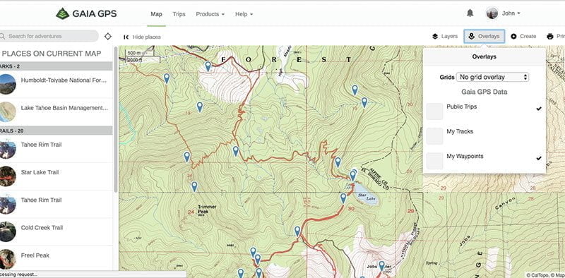

If it looks good to us we can just hit "Add to My Tracks," and it shows up in our phone's Tracks folder!
You can also create Routes and Waypoints on the web. You can't create areas, but there's a way around this. Just create a route and then when you go to that route on your phone you can convert it to an area at the bottom of the Trip Information screen.
Using Gaia with Apple Watch

Gaia GPS is available for the Apple Watch! See where you're at with literally a flick of the wrist!
Some commonly-used features are available on the three different screens this app has on the watch. This is excellent because you can do a lot of common tasks without taking your phone out!
- Start/Pause track recording
- Create waypoint
- View map (zoom in/out, locate position)
- Course & altitude information
Drawbacks of Gaia GPS
This app is of no use to you when your phone is dead. Constant access to the GPS will drain the battery faster. But this is true of all phones & apps, not just Gaia. Ways to minimize this problem:
- Dim the screen
- Put the phone in Airplane mode to turn off other radios; GPS will still function
- Keep the phone warm
- Carry a portable power device
Gaia GPS for photographers
I've found this to also be a very useful GPS app for photography, especially photography projects. I use it for planning and keeping all of my photo locations in order with notes & folders within the app - you can read how I do that here.
When I go out on a photo venture I hit the Record button. When I'm done, I stop recording.
Then when I get home, I log on to Gaiagps.com and download that track, import it into Adobe Lightroom, and voila, all of my photos have GPS coordinates written to their metadata. More information about that in this post.
What do you think of Gaia GPS?
It's the cleanest, most intuitive hiking app I've ever used. Definitely worth the price of a dinner out. The one-year Premium membership breaks down to just over $3 per month.
I'm curious to hear what you think.
Also curious if you think you know of something better! If you've used this app, how do you think it stacks up against others? I've been looking for the best hiking app for a long time, and I've stuck with this one!

With my agm x1 i can use as a GPS on my hikes without needing a weatherproof case and still have battery left over; you know: rugged phone! The cool thing about it is its price: really cheap for the specs. Well, great note ! Thank you for sahring
Wow that phone looks like a steal! Glad it's working out for you. Thanks for writing in and happy hiking!
interesting but i think you should look at "Alpine quest" (assuming your not sponsored by Gaia)
also i combine my Samsung Xcover5 with alpine quest, the xcover series Samsung are galaxy family, IP6 and have a removable battery so i simply carry several batteries and swap them out on the go...
Looks like a great app, thanks. I should note it's only available for Android at the moment.