Disclosure: This post may contain affiliate links. I earn a small commission of product sales to keep this website going.
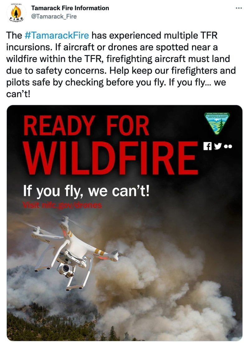
My home has been surrounded by several different wildfires over the past couple of months here in the Sierra Nevada mountains of California and Nevada. In every event, firefighting aircraft have been grounded due to drones flying near the wildfires.
While everyone wants to capture “disaster porn,” there are safe ways of doing it and unsafe ways of doing it (the ethics of it all are a different matter). Here’s my little PSA for figuring out if and where you can fly a drone near a wildfire.
This is very personal to me, and while I by no means want this to sound like a “lecture,” I want everyone to understand the domino effect of events when you fly a drone near a wildfire.
The dangers of flying a drone near wildfire
A lightning strike ignites a tree in a large, dry, dense forest. A helicopter is dispatched to drop water buckets on the fire, something that could easily stop this fire from spreading after a few trips, giving hand crews a chance to get in there and mop it up.
But as the helicopter is inbound, the ground crew notices a drone in the air and warns the helicopter. The helicopter has to turn back and the fire grows, eventually spreading to 5,000 acres in just a few hours. The fire is now out of control and will become one of the largest fires in state history, destroying hundreds of homes and injuring several firefighters.
This scenario, while hypothetical, is absolutely realistic. That’s how fast things can get out of control when the precious first few minutes are lost.
To aircraft
Firefighting aircraft need precision for dropping water, retardant, and supplies to deployed firefighters.
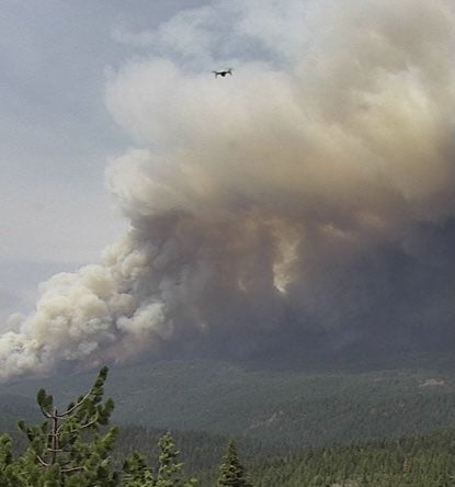
This means that they’re flying extremely low to the ground down where you fly. You may think that because they’re such large aircraft that they’re going to be well above your flight altitude. This is not the case.
Drones are extremely difficult to see from a distance from a manned aircraft. I almost hit one while flying a helicopter tour over Lake Tahoe. It was up at about 1,000 feet above the ground, well above the maximum altitude. It was slightly below me and just off my nose, but it really blended into the background. Flying a small R-44 helicopter at low speeds on a clear day, I had plenty of time to climb and navigate away from it.
Larger aircraft flying at faster speeds, lower altitudes, in smoke, with a much higher task load don’t have the luxury of time and maneuverability that I had. A drone strike can damage flight control surfaces or be ingested into an engine, causing a catastrophic engine failure. I’ve had a few bird strikes in ten years of flying F-15s and know the damage that soft birds can do. A hard object like a drone will be much worse.
Just so you can see how low & fast they fly, watch this video captured by award-winning photography instructor Jeff Sullivan during the Tamarack Fire. Jeff was documenting the fire after having been evacuated himself. These aircraft were working to protect his home. Imagine the fire approaching your home, this retardant your only hope, but then you hear the aircraft has to leave because of a drone. You can see more of Jeff’s photos from this day in this Flickr gallery. There’s a lot of unbelievable photos in there – all taken from the ground!
To everything else
It’s not just the immediate physical danger to firefighting aircraft.
These are the downstream effects when a drone is spotted near a wildfire and all aircraft are grounded:
- Fire retardant lines are not finished, leaving a wide-open path for fire to spread
- Water cannot be dropped on smaller spot fires, allowing those spot fires to rapidly grow out of control
- Firefighting personnel on the ground are put in immediate danger when water & retardant drops are cancelled last-minute
- Ground crews can’t get the supplies they need, meaning the fire can get further out of control
- Firefighters must fight in the “fog of war,” losing the strategic & tactical information that aircraft can provide
- Civilians, homes, animals, and communities are put in danger, causing loss of life and personal property
All of this can happen as the result of one 10-minute drone flight.
“I’m just going to pop the drone up really quick to snap some aerials and land.”
It doesn’t matter. All firefighting aircraft are ordered to land when your drone is detected. It can take hours before they know it’s safe to return. Think of what the fire can do unchecked during those hours. The ongoing Caldor Fire grew about 3,000 acres per hour yesterday, even with air attack.
There’s also the danger to your wallet – if you’re caught flying a drone near a wildfire, you’re technically breaking a law that says no person may interfere with firefighting operations. This can lead to fines of upwards of $20,000. Worse can happen if it results in a fatality.
Knowing where you can fly a drone near wildfire
Thankfully there are some really easy and quick ways to know if we can fly a drone or not near a wildfire.
The first is just common sense. It’s probably best to not fly if you see smoke. Especially if you see or hear any aircraft near the fire.
But that doesn’t mean you can’t fly a drone anywhere at all near a wildfire.
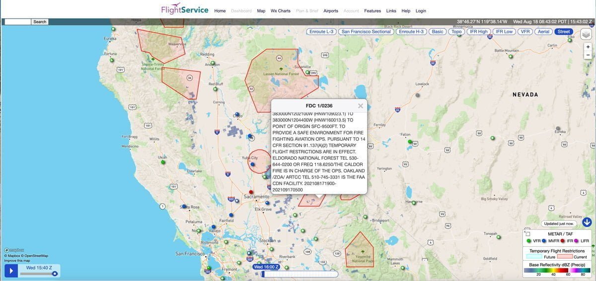
The FAA enacts what’s called a “Temporary Flight Restriction” (TFR) in areas where firefighting aircraft operate. All aircraft are prohibited from flying in a TFR, including drones. This gives firefighting aircraft the freedom to operate without the risk of colliding with another aircraft.
You’re technically legally allowed to fly outside of these TFRs (barring any other restrictions like controlled airspace, Wilderness, National Parks, etc). Does that make it safe? Not necessarily. You still need to be vigilant for aircraft coming & going.
You can check to see where these TFRs are on apps and websites.
- The official Flight Service website has an interactive map showing where these TFRs are.
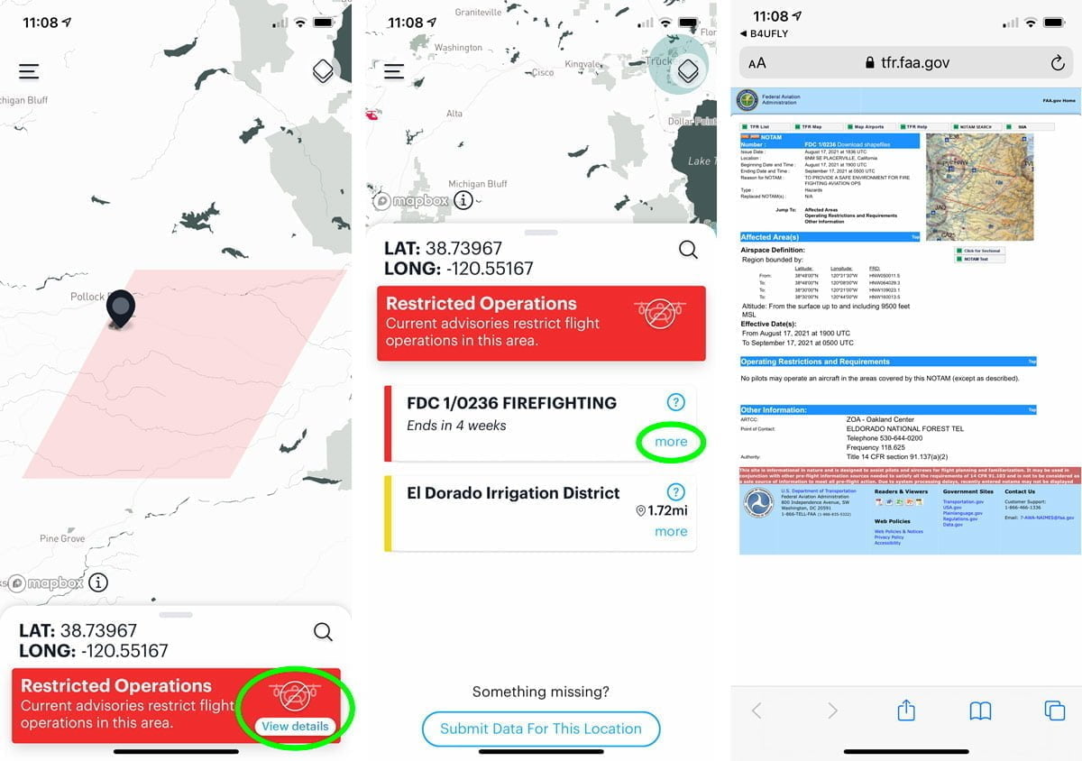
- The FAA’s free B4UFLY app has an overlay of TFRs; you can tap on them to get more information.
- Several other drone apps like AirMap and Aloft also have the same information.
With these fast, easy ways to check TFRs, there’s no excuse to not know whether or not you can fly a drone near a wildfire.
Wrapping it up
I know everyone has a little bit of FOMO and everyone wants to get that one sensational picture that no one else will get. Believe me, I’m right there with you.
Let’s give our firefighters the room they need to stop these fires. Flying a drone near a wildfire not only puts the pilots at risk. Every second they lose fighting these fires can result in loss of homes, businesses, and even loss of life.
Thanks!
Additional Resources: