Disclosure: This post may contain affiliate links. I earn a small commission of product sales to keep this website going.
John Muir Trail: Mather Pass to Mount Whitney
To view all images from this segment, and/or to purchase prints, visit my John Muir Trail: Mather Pass to Mt. Whitney photo gallery.
View the John Muir Trail Trip Report
Not every mile is represented in the photos for one reason or another. Direct journal entries in italics.
The final and most memorable, most photographed segment of the trail starting from Mather Pass (despite having the “worst” weather as far as most people are concerned). And to top it all off, we had some snow flurries at the summit of Mt. Whitney on July 4th!
Previous: Muir Trail Ranch to Mather Pass
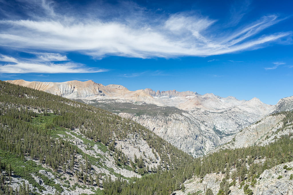
Mile 151: South Side of Mather Pass
“The hike down out of Mather Pass was easy and very beautiful, going through meadows, past small lakes, and across streams mostly above the treeline with great views.”

A hiker ascends Mather Pass from the south side. Mile 151.
Mile 152: Upper Basin

Wildflowers in Upper Basin, looking towards Striped Mountain and Mount Pinchot. Mile 152.
Mile 153: Cardinal Mountain
“Passed a girl going north who said there was a chance of lightning today and tomorrow, so we had to continue south to find a campsite below the treeline.”

Passing Cardinal Mountain in Upper Basin. Mile 153.
Mile 156: Sierra Shooting Stars
“Finally got to test out the rain gear and the tent. Dry so far! Blew a hole in my sock (toe) and heel on the other sock both on Mather Pass.”

Wildflowers in a meadow near the South Fork of the Kings River. Mile 156.
Mile 159: Towards Pinchot Pass
“First one to leave camp because clouds showed promise for morning photography. Raced up Pinchot Pass and it became overcast. Going up the pass wasn’t too bad. Bench Lake has a pretty meadow and Lake Marjorie & one below the pass are cool.”

A small lake between Lake Marjorie and Pinchot Pass. Mile 159.
Mile 161: Range of Light
“At the top the clouds started to clear so I was mesmerized by the shadows on the mountains for two hours while waiting for the rest. Back side of the pass spectacular as well, but became really steep and almost blew out my knee on those big steps.”

Looking north from Pinchot Pass. Mile 161.
Mile 162: Down Pinchot Pass

The trail passes a series of lakes and streams to the east after coming down Pinchot Pass. Mile 162.
Mile 163: Storm over Crater Mountain
“Ominous clouds came in, followed by thunder, so I raced to Woods Creek. Only got a few raindrops.”

Dark clouds create an ominous mood over Crater Mountain. Mile 163.
Mile 166: Woods Creek Waterfall

A small waterfall along Woods Creek. Mile 166.
Mile 167: Woods Creek

Woods Creek and Mount Clarence King. Mile 167.
Mile 168: Woods Creek Cascades
“At sunset went to cascade on Woods Creek because clouds promised to be spectacular. Crossed the slick granite to get a shot of cascades, Castle Dome, and the sky. Almost slipped and would have rode the waterslide of death down to a washbowl where I surely would have cracked my head. Clouds moved out and I was left with a boring sky and had to cross the creek again.”

Cascades on Woods Creek in front of Mount Clarence King, during sunset. Mile 168.
Mile 169: Woods Creek Suspension Bridge

The Woods Creek Suspension Bridge. Mile 169.
Mile 170: South Fork Woods Creek
“Left camp before everyone else and hiked out towards Glen Pass. Started out as a sunny day. Gradual climbs and neat small meadows towards Dollar Lake, first view of reflection of Fin Dome.”

A small waterfall along the south fork of Woods Creek. Mile 170.
Mile 171: Meadow Wildflowers

Sierra Shooting Stars in a meadow off the trail. Mile 171.
Mile 173: Fin Dome

A meadow on the west side of Dollar Lake, with Fin Dome seen off to the south. Mile 173.
Mile 174: Arrowhead Lake

Hikers on the trail east of Arrowhead Lake, heading towards Rae Lakes. Mile 174.
Mile 175: Rae Lakes

The north end of Rae Lakes, and the “Painted Lady” mountain behind it. Mile 175.
Mile 176: Up Glen Pass
“As we got close to Rae Lakes, clouds started moving in. Continued towards Glen Pass as everyone else took a break at Upper Rae Lake as rain started. About one mile up the pass heard thunder, took cover under trees. Waited for a while then everyone else showed up. They were going to continue to the top, as thunder was nearby, after earlier lecturing me about safety with lightning on the passes. Convinced everyone to stay, shortly after, had very close lightning within one mile. After waiting a half hour, continued up as rain went on and off.”

Looking down on the south end of Rae Lakes while heading up Glen Pass. Mile 176.
Mile 177: …Still Up Glen Pass

Hikers climbing up Glen Pass, passing the small lakes right below the pass. Mile 177.
Mile 178: Views Down Glen Pass

Virga from passing rain showers over Rae Lakes while hikers make their way up the rocks to Glen Pass. Mile 178.
Mile 181: Deer at Charlotte Lake
“Went down to Kearsarge/Charlotte junction and found Mary’s family with our resupply. Had a great evening with them and a good sunset finally. Tropical storm should hopefully be tapering off.”

Deer feed on the shores of Charlotte Lake, one mile off the John Muir Trail. Mile 181.
Mile 183: Bubbs Creek
“Can’t cinch my hip belt any tighter – did I lose that much weight? Woke up to thunder and gusts of wind that you could hear coming like an airplane. And some rain too. Hung out at camp for a while, ranger came by to visit, then left around 10:30. Wet day most of the day. Descent into Vidette was steep and muddy but I bet the meadow looks nice on clear days.”

Bubbs Creek after passing Vidette Meadow. Mile 183.
Mile 184: Bubbs Creek and Forester Pass

A clearing in the forest, looking south over Bubbs Creek towards Center Peak and Forester Pass. Mile 184.
Mile 185: Still Along Bubbs Creek

A clearing overlooking Bubbs Creek. Forester Pass shrouded in low clouds. Mile 185.
Mile 187: Kearsarge Pinnacles at Sunset
“Started climb up to camp spot ranger suggested – big site, right on the edge of the treeline below Forester Pass in case we need shelter. I just kept going without taking a break. Seemed longer than it was! Rain finally stopped around 2, welcomed blue skies. Great views here – right on the edge of the meadow at around 11,000′, creek running nearby, waterfalls on the other side of the canyon, and the views up to the mountains surrounding us. Awesome sunset down Bubbs Creek canyon with Kearsarge Pinnacles.”

Low clouds and a setting sun looking down towards the Kearsarge Pinnacles. Mile 187.
Mile 188: Up Forester Pass
“Thunderstorms moved back in around 9 last night, lasted til around 4am. Impressive light show but little sleep! And the downpour. Sprinkled on and off in the morning then I was finally able to break camp and start up Forester Pass around 8. Not an easy pass but not too bad either. Very exposed and windy all the way up to 13,200′. Ran into an Air Force Academy guy. Knows one of my fighter pilot buddies, actually lived with his parents for a summer while he was at the Academy. Way down the pass was gray and cold with occasional showers.”

Passing snow and small lakes on the way up Forester Pass. Mile 188.
…And Down Forester Pass

The trail coming off the south side of Forester Pass was cut out of the rock almost 100 years ago. Rare Sky Pilot and Alpine Gold flowers grow out of the cracks. Mile 188.
Mile 189: Donald Downs Memorial

Workers attached this plaque to the rock over 80 years ago, after the death of 18-year-old worker Donald Downs. A rusty hammer and shovel remain at the foot of the boulder. Mile 189.
Mile 191: Diamond Mesa & Mount Tyndall

A small lake below Diamond Mesa, and Mount Tyndall behind it. Mile 191.
Mile 192: Diamond Mesa

A lone tree along the trail, looking back towards Diamond Mesa. Mile 192.
Mile 195: Bighorn Plateau
“Bighorn Plateau has great views! Was going to camp there but very high and exposed, thunderstorms expected to stay. Walked another 1.5 miles down hill.”

A small lake on top of Bighorn Plateau. We had wanted to camp here this night, but because of its exposure and being the highest point in the area, that wasn’t a good idea with the sporadic thunderstorms. Mile 195.
Mile 197: Wright Creek
” Arrived at a camp that smells like shit (mules, marmots, deer, & rabbits) but cool views across the creek to Whitney. Weather finally cleared around 5pm.”

Looking towards Mt. Whitney from our campsite at Wright Creek, still two days away from the summit of Whitney. Mile 197.
Mile 199: Kern River Valley
“Got to sleep in, have breakfast, take our time, and enjoy the morning sun. No clouds! Left around 8:30. Not a bad hike with gentle switchbacks up and down to Crabtree Meadows. Nice long break there.”
Views down the Kern River Valley after climbing out of Wallace Creek. Mile 199.
Mile 200: Towards Sandy Meadow

The trail as it approaches a saddle before descending into Sandy Meadow. Mile 200.
Mile 203: Whitney Creek

Whitney Creek below Timberline Lake. Mile 203.
Mile 204: Timberline Lake

The west side of Mt. Whitney and Timberline Lake. Mile 204.
Mile 205: Guitar Lake Camp
“Two other guys at Crabtree Meadows said they were headed up to Guitar Lake to camp, so I left a few minutes later, passed them shortly after, and snagged the last big camp spot at Guitar Lake. Made it the 2.7 miles up in under an hour. Passed picturesque Timberline Lake on the way. Many hikers then started to stream in to Guitar Lake. Getting crowded here! Going to bed at 8 to wake up at 2 and start up. Can’t believe all the signs of human waste here – piles of rocks on top of TP, right next to camp sites. Became cloudy, overcast, scared of rain, but it looks like it might be clearing up.”

Camped out at Guitar Lake, ready to start up Whitney very early the next morning. Mile 205.
“No sleep at all last night. Maybe the anticipation? Or trying to go to sleep before sunset? Or the guys who set up camp right next to me at around 9pm? Either way, I was already awake when I got my 0145 wake up call. Packed up quickly and took off towards Whitney.”

Breaking camp at Guitar Lake at 2AM to guarantee an arrival on the summit of Mt. Whitney before sunrise. Mile 205.
Mile 207: Above Hitchcock Lakes
“Climbing up Whitney in the middle of the night was cool, in an expedition mountaineering kind of way, but not that tough. The moon was full two days ago and despite the cloud cover I was able to hike all the way to the summit without turning on my headlamp. Arrived about 30-45 minutes before sunrise.”

Hikers climbing the switchbacks above Hitchcock Lakes towards Mount Whitney. Mile 207.
Mile 208: Hitchcock Lakes and Guitar Lake

Guitar Lake (right), where we departed from that morning, and Hitchcock Lakes with Mt. Hitchcock behind them. Mile 208.
Mile 210: Mount Whitney Summit
“Cold and windy! Maybe six other people up there besides us. Sad on top – trash & wag bags stashed under rocks. Shortly after arriving noticed dark clouds and virga to the east. Ran around taking as many pictures as I could before the rain hit. Fingers were dark blue. Then the mountains to the west started glowing as if illuminated from within, and only a few snowflakes flurried around. Got some great pics. The rest of the crew arrived but one had altitude sickness, so we took our group photo with my flag (highest in the lower 48!) and I signed the register and headed back down.”

We started with five and ended with seven. Proud to say this was the first American flag to make it to the tallest point in the contiguous United States on this Independence Day, our two veterans in the foreground. Mile 210.

Silhouette of the survey hut on top of Mt. Whitney, the moon hidden behind passing clouds. Mile 210.

Looking west from atop Mt. Whitney at sunrise. Mile 210.

Wales Lake and the Eastern Sierras from Mt. Whitney. Mile 210.
“Switchbacks after Trail Crest sucked – so many! Groups of tourists coming up from Lone Pine looking like zombies, like they were about to keel over, and some without water! Couldn’t believe how many people did not have water. Finally got to Whitney Portal, had a burger, beers, ice cream, M&Ms, root beer, a hot dog, then went to bed around 7. Torrential rain. My Forrest Gump moment today was that I wanted to keep on going. It can’t be over, I’m not done. What’s next…?”
ricky flick
Friday 29th of January 2021
thank you! great pics and comments
Bob Wyka
Saturday 4th of July 2020
John, thank you a lot...I used your pics and descriptions to help me plan our thru hike from Happy Isles. We start in 50 days, 23Aug20. I put you a link on my board.
John Peltier
Monday 6th of July 2020
Oh cool, glad it helped! I'm doing a small segment of this again as part of a larger loop (Rae Lakes Loop) in a couple weeks and can't wait to get back to the Rae Lakes section. Beautiful. Have fun and stay safe!